Home     Daily Blog     Galleries     Maps     Contact

Showing posts with label Dixie Highway. Show all posts

Wednesday, April 20, 2022

Big Rock & Scenic Overlook - Sewanee, TN

Big Rock & Scenic Overlook - Sewanee, TN

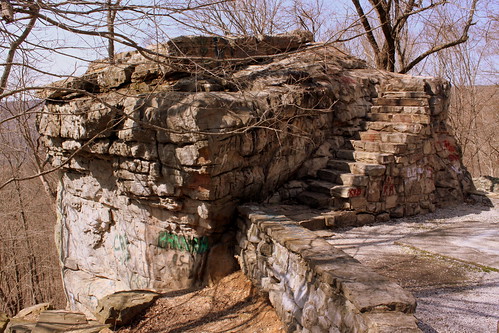
In the earliest days of cross country automobile travel, there weren't as many places to pull over and rest, so the early highway departments would add scenic stops with several parking spaces and concrete picnic tables. This would be even more important for the winding drive up a mountain, especially if it was a new or scary experience.

One of the earliest routes to ascend the Cumberland Plateau in the Monteagle area connected Sewanee at the top to Cowan down below. As the members of the Dixie Highway Association were looking for the best route to cross the plateau, they decided to reuse this early road, making improvements along the incline.

A more detailed description of this spot comes from the TDOT book Tennessee's Survey Report for Historic Highway Bridges on Page 125:
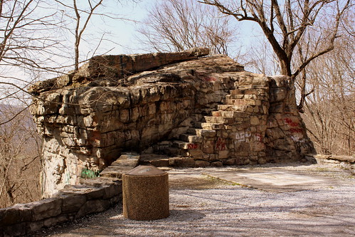
During the 1920s and 1930s, there was a growing interest nationally in scenic beautification projects along highways. These often included turnouts, or pull-offs, sometimes with small parks or picnic areas. If an impressive view existed, the turnout was called a scenic overlook. During the 1930s, beginning in 1934 in Tennessee, federal relief programs funded “Roadside Development,” “Landscaping,” and “Beautification” projects resulting in landscaping projects and a variety of roadside parks, pull-offs or turnouts, and overlooks. An example is the scenic overlook on the steep western side of Monteagle Mountain. In 1918 Franklin County issued a $300,000 bond issue for road improvements which included a joint project with the state in 1919 to improve a ten mile stretch of the Dixie Highway through the county that contained this pull-off. It is unknown if the original pull-off, which contained a sweeping 400 foot stone wall flanking a massive boulder, pre-dates the 1919 project or if it was built (or enhanced) as part of the project. In 1936 the state spent $11,190 as a National Recovery Highway Project to landscape 5.4 miles of the Cowan to Sewanee section of State Route 15 (the Dixie Highway). The 1936 project, whose plans show the location of the original stone wall, removed the older wall and erected a new wall of rubble masonry 1400 feet long, cut steps into the boulder (7” rise, 12” tread, and 30” width), and paved the parking area with macadam stone. The state also built over 900 discontiguous feet of rubble masonry walls and planted over 2100 trees and shrubbery “grouped in as natural arrangements as possible” on the project.

While the road was originally part of the Dixie Highway, and then state route TN15, eventually it became US41A/US64. (It is not US64 anymore as that route now meets I-24 and ascends Monteagle that way.) This area is right along the western edge of the Domain of the University of the South. The stone masonry that extends from the left of the boulder eventually meets up with the highway marking the western entrance of the University of the South. When you climb up the steps, you see the surface of the boulder is covered with graffiti covering graffiti. My personal favorite was "Don't fall of and die!!!" (Things dating back to the Thirties don't always have guardrails.) Even still, in the 10 minutes I was here, multiple carloads of young and old passengers stopped for family portraits.

Monday, April 4, 2022

Video: Suck Creek Highway


This is part 3 in a SeeMidTN.com series of scenic drives around Chattanooga.
There are 3 versions of this video:
Regular: https://youtu.be/ONunCvkAsO0
Extended: https://youtu.be/spKzPfTmUcQ
Extended with Commentary: https://youtu.be/Q5MfwUZshSY

Previous Scenic Drives around Chattanooga:
1) W Road - https://youtu.be/UoEMb9CCmCs
2) US127 down Signal Mountain - https://youtu.be/ezIBtEmIudE

This highway was completed in the early 1920s and was the most difficult stretch of the early North-South cross-county road, the Dixie Highway. Yet, it also became one of the most scenic stretches of the entire route.

In the commentary, I discuss how the road got its name, why it was difficult to build the road, how the Dixie Highway was rerouted and points of interest along the route.

Here is my playlist of all SeeMidTN.com presents videos:
https://www.youtube.com/playlist?list...

Sunday, October 10, 2021

Video: Suck Creek Highway Extended Version with Commentary


This is part 3 in a SeeMidTN.com series of scenic drives around Chattanooga.
There are 3 versions of this video:
Regular: https://youtu.be/ONunCvkAsO0
Extended: https://youtu.be/spKzPfTmUcQ
Extended with Commentary: https://youtu.be/Q5MfwUZshSY

Previous Scenic Drives around Chattanooga:
1) W Road - https://youtu.be/UoEMb9CCmCs
2) US127 down Signal Mountain - https://youtu.be/ezIBtEmIudE

This highway was completed in the early 1920s and was the most difficult stretch of the early North-South cross-county road, the Dixie Highway. Yet, it also became one of the most scenic stretches of the entire route.

In the commentary, I discuss how the road got its name, why it was difficult to build the road, how the Dixie Highway was rerouted and points of interest along the route.

And finally, here is my website:
http://seemidtn.com/

Friday, January 29, 2021

Harrison Mayes: Jesus is Coming Soon

Harrison Mayes: Jesus is Coming Soon

Kentuckyan Harrison Mayes survived a mining accident and spent much of the rest of his life making crosses like this one and placing them on major roads all throughout the country. This sign is in Smyrna, TN and located on the Old Nashville Highway, which is a 150+ year old road connecting Nashville to Murfreesboro and eventually became part of the Dixie Highway. These signs, made of concrete, usually weigh 1400 pounds.

On one side of the cross, it reads "Jesus is Coming Soon." The other side says "Get Right With God." Until recently, the GET was covered up and replaced with MADE. I am not sure who or why it was changed originally or restored to the original.

For more info on Harrison Mayes and his signs, Look here.

Monday, June 5, 2017

Calhoun, GA Memorial Arch with Sequoyah Statue

Calhoun, GA Memorial Arch with Sequoyah Statue

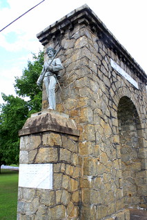
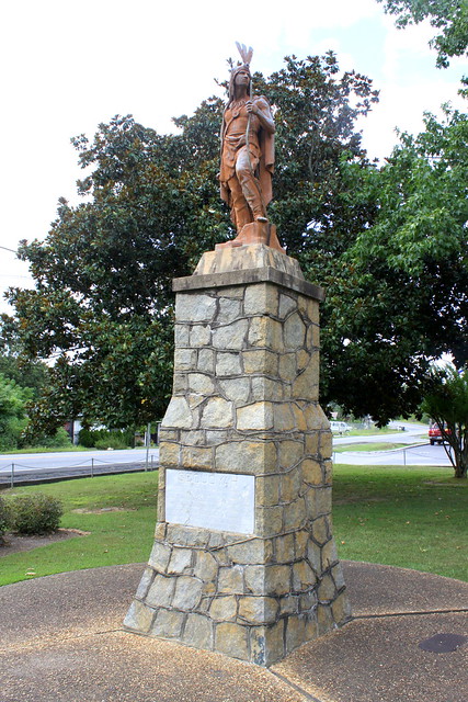
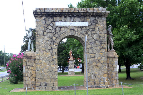
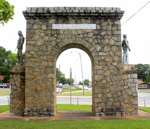
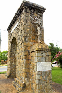
Located at the northern end of Calhoun is this memorial arch honoring soldiers. The arch is at a small triangular park where highway US41 (old Dixie Highway) meets GA225. The Arch and nearby Sequoyah statue were funded by the Calhoun Women's Club in 1927. The statues were made by JL Mott Iron Works in New York. The stone masonry was completed by W. Laurens Hillhouse.

One one side is a Confederate Memorial which commemorates the Battle of Resaca which was fought near here on May 14-15, 1864. On the other side, "Calhoun honors her World War Heroes 1917-1918" featuring a Doughboy statue.

Calhoun, GA Memorial Arch

Calhoun, GA Memorial Arch - WWI Soldier Calhoun, GA Memorial Arch - Confederate Soldier

Sequoyah Statue - Calhoun, GA

Thursday, March 30, 2017

Big Rock & Scenic Overlook - Sewanee, TN

Big Rock & Scenic Overlook - Sewanee, TN

In the earliest days of cross country automobile travel, there weren't as many places to pull over and rest, so the early highway departments would add scenic stops with several parking spaces and concrete picnic tables. This would be even more important for the winding drive up a mountain, especially if it was a new or scary experience.

One of the earliest routes to ascend the Cumberland Plateau in the Monteagle area connected Sewanee at the top to Cowan down below. As the members of the Dixie Highway Association were looking for the best route to cross the plateau, they decided to reuse this early road, making improvements along the incline.

A more detailed description of this spot comes from the TDOT book Tennessee's Survey Report for Historic Highway Bridges on Page 125:
During the 1920s and 1930s, there was a growing interest nationally in scenic beautification projects along highways. These often included turnouts, or pull-offs, sometimes with small parks or picnic areas. If an impressive view existed, the turnout was called a scenic overlook. During the 1930s, beginning in 1934 in Tennessee, federal relief programs funded “Roadside Development,” “Landscaping,” and “Beautification” projects resulting in landscaping projects and a variety of roadside parks, pull-offs or turnouts, and overlooks. An example is the scenic overlook on the steep western side of Monteagle Mountain. In 1918 Franklin County issued a $300,000 bond issue for road improvements which included a joint project with the state in 1919 to improve a ten mile stretch of the Dixie Highway through the county that contained this pull-off. It is unknown if the original pull-off, which contained a sweeping 400 foot stone wall flanking a massive boulder, pre-dates the 1919 project or if it was built (or enhanced) as part of the project. In 1936 the state spent $11,190 as a National Recovery Highway Project to landscape 5.4 miles of the Cowan to Sewanee section of State Route 15 (the Dixie Highway). The 1936 project, whose plans show the location of the original stone wall, removed the older wall and erected a new wall of rubble masonry 1400 feet long, cut steps into the boulder (7” rise, 12” tread, and 30” width), and paved the parking area with macadam stone. The state also built over 900 discontiguous feet of rubble masonry walls and planted over 2100 trees and shrubbery “grouped in as natural arrangements as possible” on the project.

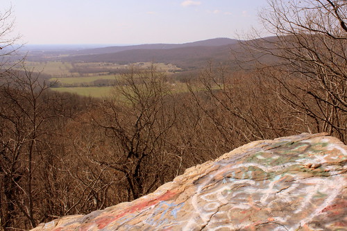
While the road was originally part of the Dixie Highway, and then state route TN15, eventually it became US41A/US64. (It is not US64 anymore as that route now meets I-24 and ascends Monteagle that way.) This area is right along the western edge of the Domain of the University of the South. The stone masonry that extends from the left of the boulder eventually meets up with the highway marking the western entrance of the University of the South. When you climb up the steps, you see the surface of the boulder is covered with graffiti covering graffiti. My personal favorite was "Don't fall of and die!!!" (Things dating back to the Thirties don't always have guardrails.) Even still, in the 10 minutes I was here, multiple carloads of young and old passengers stopped for family portraits.
Sunday, February 19, 2017

Harrison Mayes: Get Right With God

Harrison Mayes:  Get Right With God

Kentuckyan Harrison Mayes survived a mining accident and spent much of the rest of his life making crosses like this one and placing them on major roads all throughout the country. This sign is in Smyrna, TN and located on the Old Nashville Highway, which is a 150+ year old road connecting Nashville to Murfreesboro and eventually became part of the Dixie Highway. These signs, made of concrete, usually weigh 1400 pounds.

On one side of the cross, it reads "Jesus is Coming Soon." The other side says "Get Right With God." Until recently, the GET was covered up and replaced with MADE. I am not sure who or why it was changed originally or restored to the original.

For more info on Harrison Mayes and his signs, Look here.

Thursday, August 25, 2016

Judge Allison / Dixie Highway Marker

Judge Allison / Dixie Highway Marker

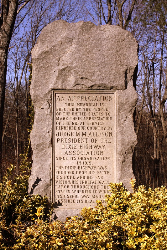
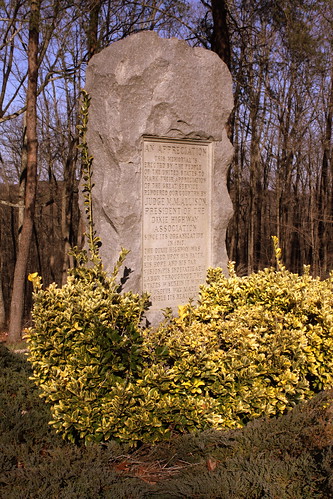
In the earliest days of American Highways, before there was the numbered route system of today, there were National Auto Trails. One of the most prominent of these trails was the Dixie Highway where the western branch connected Chicago and Miami. The first and only president of the Dixie Highway Association was judge M. M. Allison of Chattanooga. The original route through the area involved building a road up and down Walden's Ridge in the Suck Creek area, a project that lasted from about 1919-24. Since this area atop Walden's Ridge was the highest point along the Dixie Highway as well as vaguely the midpoint between Chicago and Miami, the Association decided to build a small roadside park here as well as this monument which was dedicated in 1924.

An editorial discussing the event in the Atlanta Constitution by editor Clark Howell, one of Georgia’s two directors on the Dixie Highway Association, said, “No man in the south has contributed more to the development of the south--indeed the whole country for it is a national project-- than Judge Allison in his faithful and untiring work in this one outstanding interstate highway project”

The text of the marker, which still stands, states: "This memorial is erected by the people of the United States to mark their appreciation of the great service rendered our country by Judge M. M.Allison, president of the Dixie Highway Association since its organization in 1915. The Dixie Highway was founded upon his faith, his hope and his far vision, his indefatigable labor throughout the states wherein it winds its useful way made possible its realization."

With all of the hairpin turns and difficult terrain to navigate, an alternate and more popular route between Jasper and Chattanooga was soon developed, which today is highway US41. In other words, the original Dixie Highway marker was essentially bypassed for a more convenient route, however this small pullover and monument is still there today as the road is now state highway TN27.

Judge Allison / Dixie Highway Marker

Thursday, February 25, 2016

Big Rock & Scenic Overlook - Sewanee, TN

Big Rock & Scenic Overlook - Sewanee, TN

In the earliest days of cross country automobile travel, there weren't as many places to pull over and rest, so the early highway departments would add scenic stops with several parking spaces and concrete picnic tables. This would be even more important for the winding drive up a mountain, especially if it was a new or scary experience.

One of the earliest routes to ascend the Cumberland Plateau in the Monteagle area connected Sewanee at the top to Cowan down below. As the members of the Dixie Highway Association were looking for the best route to cross the plateau, they decided to reuse this early road, making improvements along the incline.

A more detailed description of this spot comes from the TDOT book Tennessee's Survey Report for Historic Highway Bridges on Page 125:
During the 1920s and 1930s, there was a growing interest nationally in scenic beautification projects along highways. These often included turnouts, or pull-offs, sometimes with small parks or picnic areas. If an impressive view existed, the turnout was called a scenic overlook. During the 1930s, beginning in 1934 in Tennessee, federal relief programs funded “Roadside Development,” “Landscaping,” and “Beautification” projects resulting in landscaping projects and a variety of roadside parks, pull-offs or turnouts, and overlooks. An example is the scenic overlook on the steep western side of Monteagle Mountain. In 1918 Franklin County issued a $300,000 bond issue for road improvements which included a joint project with the state in 1919 to improve a ten mile stretch of the Dixie Highway through the county that contained this pull-off. It is unknown if the original pull-off, which contained a sweeping 400 foot stone wall flanking a massive boulder, pre-dates the 1919 project or if it was built (or enhanced) as part of the project. In 1936 the state spent $11,190 as a National Recovery Highway Project to landscape 5.4 miles of the Cowan to Sewanee section of State Route 15 (the Dixie Highway). The 1936 project, whose plans show the location of the original stone wall, removed the older wall and erected a new wall of rubble masonry 1400 feet long, cut steps into the boulder (7” rise, 12” tread, and 30” width), and paved the parking area with macadam stone. The state also built over 900 discontiguous feet of rubble masonry walls and planted over 2100 trees and shrubbery “grouped in as natural arrangements as possible” on the project.

While the road was originally part of the Dixie Highway, and then state route TN15, eventually it became US41A/US64. (It is not US64 anymore as that route now meets I-24 and ascends Monteagle that way.) This area is right along the western edge of the Domain of the University of the South. The stone masonry that extends from the left of the boulder eventually meets up with the highway marking the western entrance of the University of the South. When you climb up the steps, you see the surface of the boulder is covered with graffiti covering graffiti. My personal favorite was "Don't fall of and die!!!" (Things dating back to the Thirties don't always have guardrails.) Even still, in the 10 minutes I was here, multiple carloads of young and old passengers stopped for family portraits.
Friday, January 22, 2016

Martin Springs

Martin Springs

Martin Springs seems like it should be one of the most interesting places to visit in Tennessee, and yet I've had trouble finding anybody who had ever heard of it.

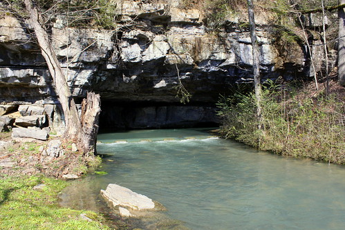
This interesting geologic feature is located in Battle Creek Valley not far from where Interstate 24 ascends Monteagle on the east side of the mountain. This is the entrance to a water-filled cave and it is said that the springs have 6500 gallons of water flow out of it every minute forming Battle Creek!

Some of the earliest history to occur here was this was along the Bell Route of the Trail of Tears and the area was used as a campsite by the Cherokee in 1838. There is a historic marker here that notes the Trail of Tears as well as Civil War Battles that took place here.

The Dixie Highway, one of the earliest cross-country highways in the country, passed right by this spring. Thornton Herbert Martin bought the land at the spring and soon opened Martin Springs Tourist Camp which offered cabins and a boardinghouse for the early highway travelers. Back then, anyone who had a spring advertised the supposed healing properties of the water. Eventually this segment of the Dixie Highway became US41 and was much traveled for many years until the interstate came through the area and US41 was rerouted. I'm not sure when the tourist cabins closed but an interstate makes it tougher to stop at spur-of-the-moment places such as this.

2021 Important update! In this post, I previously documented how I confirmed this location was open to the public and then provided directions how to find it. In April 2021, the owner contacted me and clearly said visitors are no longer permitted. I recommend you respect his wishes.

Tuesday, August 25, 2015

Tennessee Highway 2

Tennessee Highway 2

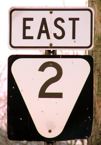
Single digit state highway signs are some of the toughest to find. They tend to mark what the state originally considered the most important routes across Tennessee, but usually become bundled with U.S. routes. The state markers were systematically removed so to not confuse motorists. As of today, I have found signs of 1, 2, 3, 5, 6, 7 & 8.

The best that I can tell, TN2 was the route from Nashville to Chattanooga. This route was originally the Dixie Highway but eventually became the important US41. When Interstate 24 was constructed, that alleviated traffic off of US41/TN2. After Chattanooga, TN2 went to Knoxville.

There are only so many ways you can get down off of Monteagle. Interstate 24 on the east side of Monteagle became where US41 had been, and US41 between Monteagle and Jasper were reroute through Tracy City over what used to by TN150. In the 80's, road officials felt both directions of I-24 going through that area wasn't getting the job done and a massive construction project was done for new eastbound lanes coming down the mountain. Now the westbound lanes going up the hill is what the Dixie Highway / US41/US64/TN2 Used to be.

Once you're at the base of the incline, TN2 is still there, as it parallels I24 from exits 143 to 152. I would suspect this highway now gets very little traffic, from the locals and from roadgeeks like me.

Tuesday, August 18, 2015

Wonder Cave, an old sign pointing to

Wonder Cave, an old sign pointing to

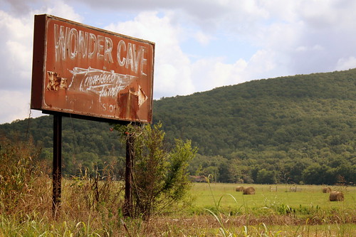
This sign points the way to Wonder Cave, once a popular middle Tennessee tourist attraction.

The cave is located at the base of Cumberland Plateau in Grundy County. Back in the days of the Dixie Highway and later highway US41, the turn to get to the cave was located at the last turn before making the ascent to Monteagle. Everyone travelling from Nashville to Chattanooga would have passed through here.

As has been the case with many "impulse" tourist attractions, the opening of the interstate killed off this business. Now people take I-24 through the area and the Cave soon went out of public. It reopened again but soon closed again circa 2000. Even though it's not open commercially these days, I hear it's possible to get in the cave if you do a little research.

Wednesday, November 20, 2013

Unnamed waterfalls seen along the old Dixie Highway in the Winter

Unnamed waterfall one seen along the old Dixie Highway

When the founders of the Dixie Highway were planning their route from Nashville to Chattanooga, one of their biggest obstacles was deciding how to get over or around Walden Ridge. One method was to go around the ridge completely by placing a bridge over the Tennessee River. Eventually, they chose the river option with the building of the Marion Memorial Bridge. However, the original route crossed over the ridge along a route that today is known as highway TN27 or Suck Creek Rd.

While undertaking the difficult task of constructing a road down the east slope of the ridge, they were mindful of their surroundings. Suck Creek Road follows the path of Suck Creek as it drains down the side of the mountain. I'm sure this creek has multiple spectacular cascades, rapids and plunges but only the most adventurous outdoors people might ever be able to fully explore them. Luckily, the view here didn't require much effort.

There are a couple of wide pulloffs along the highway to stop and see some smaller trickles. The day I took this picture, it was in the winter on the day after a heavy rain so I really don't know if this is something worth finding year round or if it is more of a wet weather falls. The water seen here eventually goes into a pipe underneath the highway and eventually drains into Suck Creek.

Unnamed waterfall two seen along the old Dixie Highway

Tuesday, May 14, 2013

Martin Springs

Martin Springs

Martin Springs seems like it should be one of the most interesting places to visit in Tennessee, and yet I've had trouble finding anybody who had ever heard of it.

This interesting geologic feature is located in Battle Creek Valley not far from where Interstate 24 ascends Monteagle on the east side of the mountain. This is the entrance to a water-filled cave and it is said that the springs have 6500 gallons of water flow out of it every minute forming Battle Creek!

Some of the earliest history to occur here was this was along the Bell Route of the Trail of Tears and the area was used as a campsite by the Cherokee in 1838. There is a historic marker here that notes the Trail of Tears as well as Civil War Battles that took place here.

The Dixie Highway, one of the earliest cross-country highways in the country, passed right by this spring. Thornton Herbert Martin bought the land at the spring and soon opened Martin Springs Tourist Camp which offered cabins and a boardinghouse for the early highway travelers. Back then, anyone who had a spring advertised the supposed healing properties of the water. Eventually this segment of the Dixie Highway became US41 and was much traveled for many years until the interstate came through the area and US41 was rerouted. I'm not sure when the tourist cabins closed but an interstate makes it tougher to stop at spur-of-the-moment places such as this.

Martin Springs

2021 Important update! In this post, I previously documented how I confirmed this location was open to the public and then provided directions how to find it. In April 2021, the owner contacted me and clearly said visitors are no longer permitted. I recommend you respect his wishes.

Martin Springs

Saturday, March 23, 2013

Marion Memorial Bridge update

Marion Memorial Bridge (Fall 2012 Update)

This bridge was built in 1929 to cross the Tennessee River for a new alignment of the Dixie Highway. Originally, there were toll booths on either side but they were removed in 1947. In the mid 1960's with the building of Nickajack Dam just downstream, which formed Nickajack Lake, the water level rose. The Bridge was rehabilitated and also hydraulically lifted 21 feet so that barge traffic could still pass below. While not the Dixie Highway anymore, it did carry the Cummings Highway, which is US41, US64 and US72.

After Interstate 24 was built near the same place, traffic on this bridge shrank. A friend of mine who lived in the area told me how she always hated driving across this bridge because it is narrow and you fell like you could fall off the side. The bridge was added to the National Register of Historic Places in 2007.

Recently, the bridge was determined by the state to be structurally deficient. Early in the year, on Jan. 9, 2012, the bridge was officially closed. In a couple of years, there will be a new, wider bridge at this location. For the full story, read this article:
www.timesfreepress.com/news/2011/dec/28/tdot-to-close-mar...

Friday, March 22, 2013

Acworth, GA Caboose

Acworth, GA Caboose

Main Street of Acworth is part of the old Dixie Highway which is now Old US highway 41. This caboose with the Acworth logo on it is near the downtown historic district

Monday, November 5, 2012

Dixie Motel sign - Indian Hills, GA

Dixie Motel sign - Indian Hills, GA

Located along the old Dixie Highway and current US41, somewhere in Catoosa County, GA between Ringgold and the Tennessee state line.

Saturday, October 13, 2012

Would be a pity to miss Rock City

Would be a pity to miss Rock City

I suppose one thing my photostream is known for is the extensive collection of Rock City barns. I drive the backroads whenever I can and stumble across some that way. However most of the barns that I photograph are already known by the community at large, such as the Rock City Barn book that they commissioned about 15 years ago, or websites such as ohiobarns.com. If it's to be found, then I've found it. Or so I thought.

About a month ago, a reader of my website named Steve wrote me. He likes looking for the barns, too. He found a barn that I missed, the book missed and I suppose everyone who's posted their barn shots on the internet has missed, too. And, it's in my home county! (That's the part that really got under my skin.) It's along US41, just about a mile away from one that I have photographed.

I'm not sure how many times I've driven right past it. There weren't really any trees or other obstructions blocking the view, but the roof is rather rusty making it a tough read.

For those of you keeping score at home, and I'm not sure why anyone would, this is one of over 75 different Rock City barns I have posted to flickr. Would be a pity to miss this barn ever again. Have you ever wished there was a convenient way to find all of the Rock City Barns that are still out there? Well, that's what I've tried to do on my website. On my Map of Rock City Barns page, I have plotted each barn on a Google Map.

Saturday, August 25, 2012

A very faded Rock City barn

A very faded Rock City barn

it says(I think):

SEE BEAUTIFUL
ROCK CITY
LOOKOUT MT.
Chattanooga, Tenn

although I can't see it, usually there's a "Atop" before Lookout Mt. and a "near" before Chattanooga, tn

My wife and I were driving North from Nashville to Louisville and we both loke country driving off the interstates. One good section of highway we'd never taken was U.S. Highway 31W north of Cave City, Ky into Louisville. In the past, we had driven 31W from Cave City to Bowling Green as there are some Rock City barns there.

Most drives between two big cities have one major highway, but Nashville to Louisville have 2: 31E and 31W. Both are very old routes. 31E goes by Lincoln's Birthplace as the Lincoln's lived on that route which became 31E. Dixie Highway, which was the major tourism route from Chicago to Miami in the dawn of auto travel in the 1920's in this area has become 31W.

Since we were driving North, if we were to spot a Rock City ad, we'd have to turn around to see it as they would only be useful for people going in the right direction. Most Rock City barns I know about before we get to it, based on other people's pictures online. There's also the most thorough collection in the Rock City Barns book by David Jenkins. However, if a barn appears in that book from about 12 years ago and it's doesn't appear in someone's online collection, that often means it's gone.

When I drive down a highway like this, I always have a tendancy to look behind me at every prime location of a barn we pass just to make sure we aren't missing anything. Occasionally, I say "That would make a good one" when I see a barn with a big side that faces oncoming traffic, as my wife humors me and nods. For the first time, I was right. I noticed the huge roof on the north side of the barn, which make for the perfect sign for southbound traffic.

This barn is in Hardin County, KY, but 31W through here serves as the border between Hardin and Larue counties. I-65 runs very close to 31W through here and can be seen not far away. This barn is about a mile south of the intersection with KY Highway 84.

A tough to read Rock City barn

Sunday, June 10, 2012

Battle Creek Baptist Church

Battle Creek Baptist Church

Along the Old Dixie Highway (TN2) in Marion County, TN. Not only does the building look old, but the sign proclaiming the name of the church was old and nearly impossible to read. The highway parallels Interstate 24 through here and you can see this building from the interstate.

The building was built in 1904 and at the time it was Ebenezer Baptist Church.