Home     Daily Blog     Galleries     Maps     Contact

Showing posts with label river. Show all posts

Sunday, August 22, 2021

Fathers' Memorial & Overlook - Fayetteville, TN

Fathers' Memorial & Overlook - Fayetteville, TN

Fathers' Memorial & Overlook is a part of Stone Bridge Park in Fayetteville, TN. This area overlooks the Elk River close to where Norris Creek joins.

This may be a lesser-known feature of Stone Bridge Park as you have to take a paved trail which goes under the US64 bridge.

Sunday, April 23, 2017

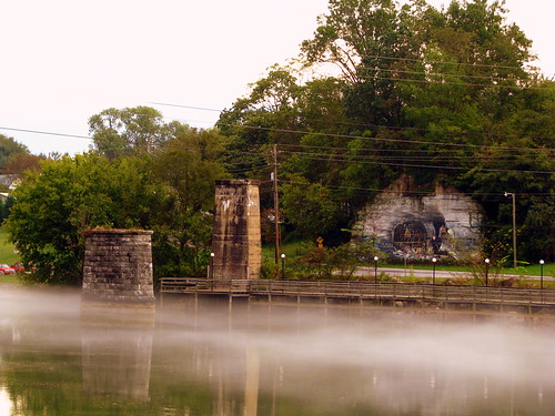
Mist on the Holston River @ Bluff City, TN

Mist on the Holston River @ Bluff City, TN

Bluff City is a town that went through multiple name changes but dates back to 1780 when the Overmountain Men crossed the Holston River here at Choate's Ford. The remains of a railroad bridge can also be seen here, with a stone pier and an abutment with a mural painted on it. (This location now has a new mural painted here.) Today, this section of the river is also known as Boone Lake.

Thursday, September 22, 2016

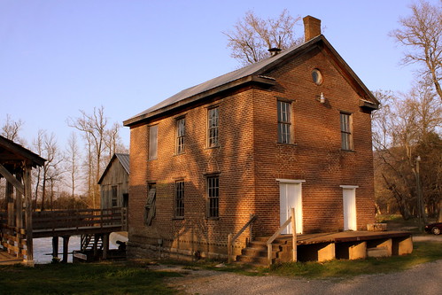
Ketner's Mill on the Sequatchie River

Ketner's Mill

Orphan David Ketner moved to the Sequatchie Valley in 1824 and opened a grist mill in an area today known as Ketner's Cover at the base of Suck Creek Mountain. His son Alexander bought a new site along the Sequatchie River in 1868 and completed the brick grist mill seen here in 1882 where it remained in operation until 1955.

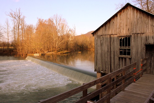
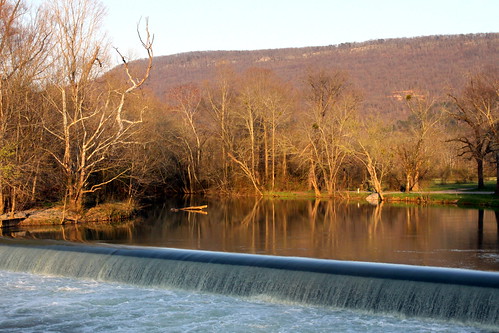
Ketner's Mill Dam

A couple of decades later, the Ketner family undertook a new beginning for the mill ushering in a new era. After undergoing a restoration, the mill was reopened in 1977 along with the first annual Ketner Mill Country Fair. That same year, the mill was added to the National Register of Historic Places. The mill continued to be operated year round until 1992 upon the death of mill operator Clyde Ketner, grandson of David Ketner.

The yearly Ketner's Mill Country Arts Fair is still going strong. held every fall, the 2016 event will be the 40th year. Still owned by the same family, now the 5th generation runs the mill, but only for a short period every year to make enough flour to sell at the yearly fair.

Ketner's Mill Dam

Wednesday, May 29, 2013

In the News: Teen survives scare at McMinnville Dam

Railroad Bridge over Barren Fork - McMinnville, TN

The Dam seen here was in the news yesterday. Here is the NewsChannel5.com story of a teen who was carried away by the current of the river and nearly pulled over the 25 foot tall day and had to cling to the top of the dam until rescue personnel could arrive.

Originally, there were multiple mills up and down the river through here, but in 1902, a hydroelectric dam was built, but is not in use anymore. According to a photo on the historical marker nearby, this bridge was already here when the dam was built. The dam is on the National register of Historic Places.

On the day I took this photo two summers ago, there were a couple of teens sitting underneath the bridge along the piers. Can you see them? If not, click the photo to see an enlarged version.

Tuesday, May 14, 2013

Martin Springs

Martin Springs

Martin Springs seems like it should be one of the most interesting places to visit in Tennessee, and yet I've had trouble finding anybody who had ever heard of it.

This interesting geologic feature is located in Battle Creek Valley not far from where Interstate 24 ascends Monteagle on the east side of the mountain. This is the entrance to a water-filled cave and it is said that the springs have 6500 gallons of water flow out of it every minute forming Battle Creek!

Some of the earliest history to occur here was this was along the Bell Route of the Trail of Tears and the area was used as a campsite by the Cherokee in 1838. There is a historic marker here that notes the Trail of Tears as well as Civil War Battles that took place here.

The Dixie Highway, one of the earliest cross-country highways in the country, passed right by this spring. Thornton Herbert Martin bought the land at the spring and soon opened Martin Springs Tourist Camp which offered cabins and a boardinghouse for the early highway travelers. Back then, anyone who had a spring advertised the supposed healing properties of the water. Eventually this segment of the Dixie Highway became US41 and was much traveled for many years until the interstate came through the area and US41 was rerouted. I'm not sure when the tourist cabins closed but an interstate makes it tougher to stop at spur-of-the-moment places such as this.

Martin Springs

2021 Important update! In this post, I previously documented how I confirmed this location was open to the public and then provided directions how to find it. In April 2021, the owner contacted me and clearly said visitors are no longer permitted. I recommend you respect his wishes.

Martin Springs

Friday, March 30, 2012

Fort Donelson #7185 - Dover, TN

Fort Donelson #7185 - Dover, TN

During the Civil War, the Confederacy was vulnerable to warships coming down the Tennessee and Cumberland rivers. Kentucky declared neutrality during the war, so the Confederates looked for a place near the the border where they could defend the river. About a mile north of Dover and about 10 miles downstream along the Cumberland River from the Kentucky Border was the site of this fort. At this location, the river has a lengthy straight path before a bend and the bluffs above the river provided a great location for a battery to shoot down any Union boat that would try to come through. In Feb. 1862, Union General Ulysses S. Grant led troops to capture this fort so that the Union could send ships through here.

When I was in 6th grade, my class visited this spot on the way to an overnight stay at Land Between the Lakes and it's something that has stuck in my mind over two decades later.

Today with a dam upstream, the Cumberland River is also Lake Barkley, but the width of the waterway is about the same as it was during the war. Fort Donelson is under the oversight of the National Park Service and is designated a National Battlefield and on the National Register of Historic Places. The lower batteries have been rebuilt and preserved here. The Upper batteries are also preserved and is located around the bend. The cannon shown here has a date of 1846 etched in the side.

Wednesday, December 21, 2011

A Riverboat and a Courthouse

A Riverboat and a Courthouse

Today, the blog takes us way north of Middle Tennessee, all the way to the northern end of Kentucky. Here are two vintage things that don't get seen together all that often. This view as you can see is taken from across the river in downtown Cincinnati.

In the foreground, Docked along the banks of the Ohio is the Cincinnati Belle Riverboat. In the background, a couple of blocks away, is the Campbell County Courthouse of Newport, Ky.

Saturday, February 26, 2011

The Still Waters of the Piney River

The Still Waters of the Piney River

The Piney River runs through Hickman County until it eventually empties into the Duck River. There's a small little area to pull over and look around where highway TN230 crosses the river near Nunnelly.

Friday, January 29, 2010

The Nashville City Park that Time forgot

The Nashville City Park that Time forgot

Lock One Park may be on your Nashville map, but you don't want to go there. This place was built in 1890, and was used as a ferry and a boat dock, then the US Army Corps of Engineers made it as one of the 14 Locks on the Cumberland River, but when the dam was built forming Old Hickory Lake, there was no need for a lock here, and the land was given to the city for a city park in the 1950s.

from there, I am not sure what happened. If you go today, you can park on the street right next to the area. A chain link rope suggests you should stay away. The location is full of concrete steps, rusty guardrails, a couple of tracks that lead down to water level, and a bunch of things that look genuinely unsafe.

Abandoned incline tracks at abandoned park

I thought I would never see anybody here, but I have. This spot is across the river from Metrocenter, and you can see this place from the levee greenway. The day I walked that greenway, a family of four was here with all of the boys fishing.

Ironically, Lock Two Park is also old and crusty, but a place you can take your kids.

If I were to pan the camera to the right in the top photo just a little bit, you'd see downtown. If you look closely on the top right, you'll see the green road signs of where I-65 crosses the river.

Recommended reading: The parks of Nashville: A history of the Board of Parks and Recreation