Home     Daily Blog     Galleries     Maps     Contact

Showing posts with label Cumberland River. Show all posts

Sunday, September 26, 2021

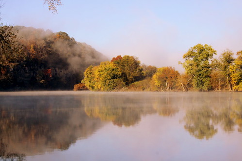
Fall Morning on the Cumberland River

Fall Morning on the Cumberland River

On this morning, there is still a little bit of fog left on this October Autumn morning. This scene is in Rome, TN in Smith County at the site of a historic ferry crossing.

Thursday, March 25, 2021

Autumn Morning at the River Confluence

Autumn Morning at the River Confluence

This scene is taken from Smith County, TN where Round Lick Creek meets the Cumberland River. At this spot near the small community of Rome was a historic ferry that crossed the Cumberland. I was here on an Autumn morning before all the morning fog had burned off.

Sunday, January 31, 2021

Nashville Bridge Company Building

Nashville Bridge Company Building

In 1908, this building was built as the headquarters of Arthur Dyer's Nashville Bridge Company. To build the Titans NFL stadium and adequate parking, most of the unused industrial buildings of the complex were torn down, but this building remained with its two additions. It was vacant for a couple of decades, but has been redeveloped over the last few years for offices and an event venue. This view is from the Shelby Street Pedestrian Bridge.

Wednesday, January 27, 2021

Cumberland City Ferry

Cumberland City Ferry

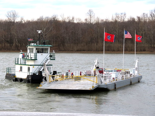
As a kid, my mom once took me along on an errand run. Along the way, she took me way out of the way to get where we were going. She had us cross the Cumberland River at the Old Hickory Blvd. Ferry. After we had crossed, she told me, "We came this was so you could ride on the ferry. You may never ride on one again." I wish that I had been old enough to appreciate it.

It's tough for a ferry to remain open these days. If the traffic slows down, the ferry goes out of business. If the traffic gets busier, the locals ask the state to build a bridge. I've been to many former ferry sites in Tennessee, but as of now, only two remain. (The other is the Danville Ferry, about 20 miles from here, which crosses the Tennessee River near Big Sandy.)

This ferry is located at the town of Cumberland City in Stewart County. The ferry allows highways TN46 & TN233 to cross the Cumberland River seven days a week. A one way ride costs a dollar, but locals get a discount.. Even this ferry "Patience" replaced an older ferry: www.tn.gov/tdot/article/ferryservices-cumberlandcityferry

Watch my video of the crossing: www.youtube.com/watch?v=88WjqYPDTGY

Tuesday, January 5, 2021

Cordell Hull Bridge (2014 reopened) driving view - Carthage, TN

Cordell Hull Bridge (2014 reopened) driving view - Carthage, TN

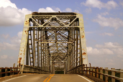
Originally Built in 1936 and recently reopened, the Cordell Hull Bridge crosses the Cumberland River in Carthage, TN.

Work on the bridge began in 1934 and is named after the former US Secretary of State Cordell Hull who lived in the area. The bridge is a 3 span continuous truss at a length of 1412 ft. with the main span over the river at 316 ft. The southwest side of the bridge reaches highway US70N which runs along a bluff near the river. The northwest side intersects with Main St. near the city's central business district. The bridge was added to the National Register of Historic Places in 2009.

The bridge was closed in 2007 when a routine TDOT inspection found the superstructure was in critical condition. Repairs began in August 2011 and they replaced all of the concrete bridge deck and guard rails. The remaining truss, lattice work and rivets were preserved with blast cleaning and then painted white. (It had been green.) The bridge reopened on July 2, 2014.

Thursday, December 31, 2020

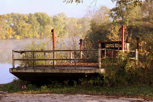
Abandoned Rome, TN Ferry

Abandoned Rome, TN Ferry

Located at the beginning of Lick Creek, the ferry crossing at Rome, TN in Smith County traversed the Cumberland River dating back to 1830. The ferry seen here was built 65 years ago.

In 1949, the "Jere Mitchell" cost $11,000 and would allow four cars to cross the river. Back then, there were 33 ferries that operated in the state, but now there are only two. The ferry ceased operation in 1992 and has been resting and rusting on the southern shore ever since. The ferry was added to the National Register of Historic Places in 1986 and you can still get up close to this relic - until vandals do even worse damage.

Tuesday, April 28, 2020

Nashville Skyline from East Bank Landing

Nashville Skyline from East Bank Landing

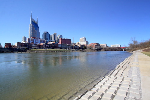
The relatively new East Bank Landing (a.k.a. Riverfront Landing) is on the east bank of the Cumberland River across from downtown. The Landing opened in Sept. 2015 and is adjacent to Cumberland Park, the East Bank Greenway and parking for Nissan Stadium.

Wednesday, April 11, 2018

In the news: Lake Barkley Bridge demolished

Henry R. Lawrence Memorial Bridge

Henry R. Lawrence Memorial Bridge
Also known as the Lake Barkley US68 Bridge in Trigg County, KY, this was built in 1932 to cross the Cumberland River. With the building of Barkley Dam in 1966, the river became Barkley Lake, so the bridge had to be raised and extended. The main through truss is about 320 feet long and the total length is 3,104 feet.

Here is some video of the crossing the three historic bridges at Land Between the Lakes:
www.youtube.com/watch?v=DsUjtvvqyNs

This bridge was demolished on April 11, 2018. You can see a news clip with video at this link.

Monday, September 4, 2017

Tater Knob Scenic Overlook

View of Cordell Hull Lake from Tater Knob

Happy Labor Day! Here's a scenic overlook that you can visit today.

Tater Knob Scenic Overlook

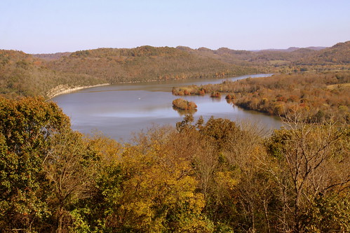
Tater Knob is a mountain in Smith County. At the top is an observation deck which provides a scenic overlook of Cordell Hull Lake and Dam.

Telephoto View of Cordell Hull Lake from Tater Knob

Cordell Hull Dam (View from Bearwaller Gap Overlook)

According to Wikipedia:
Cordell Hull Lake is a lake in the Cumberland River in north-central Tennessee, about forty miles east of Nashville, in the vicinity of Carthage. It covers approximately 12,000 acres.

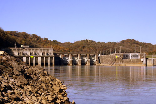
Cordell Hull Dam impounding the Cumberland River was built by the United States Army Corps of Engineers between May 1963 and November 1973 for navigation, hydroelectric power generation, and recreation. The dam is concrete and earthen gravity structure, 87 feet high (above streambed), with a generator capacity of 100 megawatts. It impounds 259,100 acre feet at normal maximum pool, with a maximum flood storage of 310,900 acre feet.

Both are named for Cordell Hull, former United States Secretary of State.

Tuesday, August 22, 2017

Cheatham Lock & Dam

Cheatham Lock & Dam

Cheatham Lock & Dam is downstream from Ashland City along the Cumberland River in Cheatham County.

From the US Army Corps of Engineers website:
www.lrn.usace.army.mil/Locations/NavigationLocks/Cumberla...

Cheatham Lock is located at Mile 148.6 on the Cumberland River in Cheatham County, Tennessee and is approximately 10 miles northwest of Ashland City, Tenn. Cheatham Lock is open to pass navigation traffic 24 hours-a-day, 365 days a year.

The 67-mile reservoir created by Cheatham Dam provides Nashville and middle Tennessee with a stable water supply and access to the entire Mississippi River system and the Intracoastal Waterway and plays an integral part in various commodities being transported to the region by water.

Cheatham Lock and Dam was authorized by Congress in 1946 as a navigation project to enhance the development of the Cumberland River Basin. Construction on the Lock was begun in 1949. Cheatham Lock was opened to navigation traffic on August of 1951. The lock chamber is 800-foot long and 110-foot wide. During normal lake levels, the lock will lift a boat 26-foot from the river below the dam to the lake above the dam. The lock releases over 17 million gallons of water each time is emptied.

Due to geological conditions in the area, the site selected for construction presented unique challenges on designing the project. This is the only lock in the Nashville District that was designed to flood; the lock walls had to be built according to the elevations of the surrounding land. Thus, create a design so that flood waters could flow over the structure with minimal damage when waters receded.

The lock has been submerged on several occasions, but the historical record-breaking flood of May 2010 submerged the lock and operations building in water almost fifteen feet deep. This far exceeded the designed limits for the structure and caused the Nashville District to perform a complete electrical overhaul and hydraulic rehab of the lock. Temporary repairs and clean-up were made and the lock was able to reopen to navigation traffic under restricted operation approximately 14 days after the waters receded. It was the middle of June 2010 before the lock returned to 24 hour operations.

Monday, March 27, 2017

Cumberland River Pedestrian Bridge

Cumberland River Pedestrian Bridge View #1

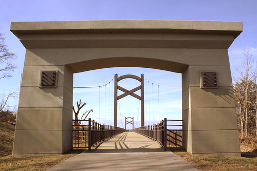
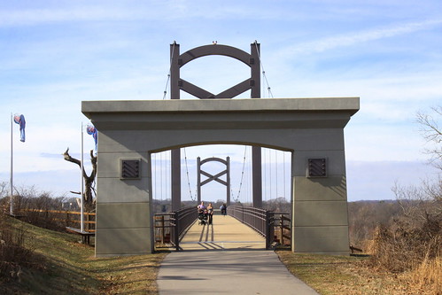
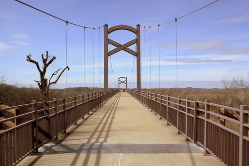
There are 15 bridges that cross the Cumberland River in Nashville, and this one is the newest after it opened in 2008. It is one of two pedestrian bridges, but the first one built specifically for that purpose. In it part of the Nashville Greenway system connecting Two Rivers Park on the south to Shelby Bottoms on the north. For more info: www.americantrails.org/resources/structures/Cumberland-Ri...

Cumberland River Pedestrian Bridge View #5

Friday, March 24, 2017

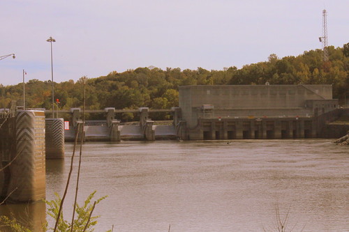
Cordell Hull Dam

Cordell Hull Dam

According to Wikipedia:
Cordell Hull Lake is a lake in the Cumberland River in north-central Tennessee, about forty miles east of Nashville, in the vicinity of Carthage. It covers approximately 12,000 acres.

Cordell Hull Dam impounding the Cumberland River was built by the United States Army Corps of Engineers between May 1963 and November 1973 for navigation, hydroelectric power generation, and recreation. The dam is concrete and earthen gravity structure, 87 feet high (above streambed), with a generator capacity of 100 megawatts. It impounds 259,100 acre feet at normal maximum pool, with a maximum flood storage of 310,900 acre feet.

Both are named for Cordell Hull, former United States Secretary of State.

Wednesday, March 22, 2017

Carthage, TN lighthouse

Carthage, TN lighthouse

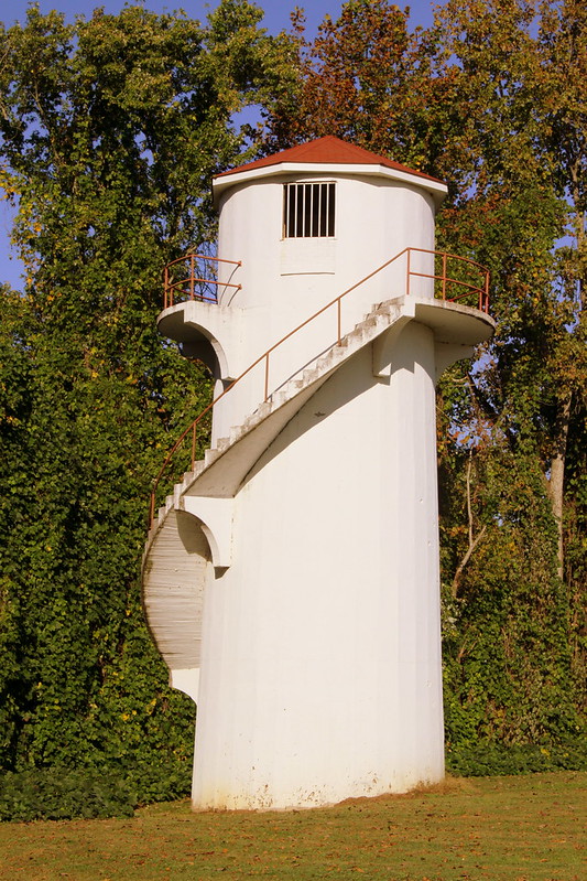
Near the bank of the Cumberland River in Carthage, TN is this lighthouse. The lighthouse is a masonry tower about 36 ft tall with a spiral staircase leading up to the gallery.

I can't find almost any information on this lighthouse, such as the date is was built. It is not listed with the U.S. Coast Guard, which means it never had the purpose of an aid to river navigation. This means that it was built for recreation or decorative purposes. If you know more, please share in the comments.

Saturday, February 11, 2017

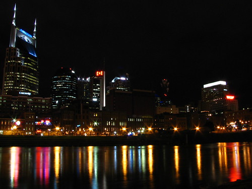
Nashville Skyline at Night in 2007

Nashville Skyline attempt #3

This is what the Nashville skyline looked like a decade ago.

Friday, February 5, 2016

Fort Donelson Battery - Dover, TN

Fort Donelson Battery - Dover, TN

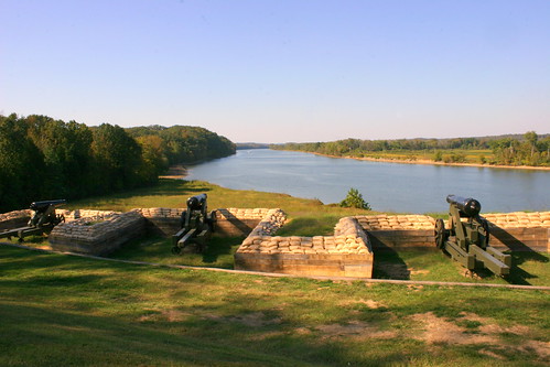
During the Civil War, the Confederacy was vulnerable to warships coming down the Tennessee and Cumberland rivers. Kentucky declared neutrality during the war, so the Confederates looked for a place near the the border where they could defend the river. About a mile north of Dover and about 10 miles downstream along the Cumberland River from the Kentucky Border was the site of this fort. At this location, the river has a lengthy strait path before a bend and the bluffs above the river provided a great location for a battery to shoot down any Union boat that would try to come through. In Feb. 1862, Union General Ulysses S. Grant led troops to capture this fort so that the Union could send ships through here.

When I was in 6th grade, my class visited this spot on the way to an overnight stay at Land Between the Lakes and it's something that has stuck in my mind over two decades later.

Today with a dam upstream, the Cumberland River is also Lake Barkley, but the width of the waterway is about the same as it was during the war. Fort Donelson is under the oversight of the National Park Service and is designated a National Battlefield and on the National Register of Historic Places. The lower batteries have been rebuilt and preserved here. The Upper batteries are also preserved and is located around the bend. The cannon shown here has a date of 1846 etched in the side.

Saturday, January 2, 2016

Nashville Skyline at Dusk 2014

Nashville Skyline at Dusk 2014 #4

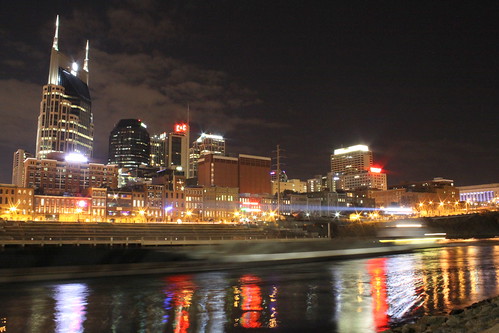
Every time I decide to take a photo of the Nashville Skyline, there seems to be a subtle change. The most notable difference I see is that the old CVS/Caremark building is now the Baker Donaldson building. Also of note, with the new park on the east shore, the boat ramp I used to set up at is no longer available.

While I was taking this long exposure still photo, I had a second camera setup to take a time lapse video. See it here:
www.youtube.com/watch?v=_GT_DhuMkNA

Technical details: This photo was taken on 2/1/2014 when sunset at 5:13 pm. This was at 6:32pm, 5sec., f/16, ISO1600. Also, there was a barge going by during this photo and you can see the barge and its headlight.

Tuesday, November 10, 2015

Cumberland River Pedestrian Bridge

Cumberland River Pedestrian Bridge View #2

There are 15 bridges that cross the Cumberland River in Nashville, and this one is the newest after it opened in 2008. It is one of two pedestrian bridges, but the first one built specifically for that purpose. In it part of the Nashville Greenway system connecting Two Rivers Park on the south to Shelby Bottoms on the north. For more info: www.americantrails.org/resources/structures/Cumberland-Ri...

Saturday, October 24, 2015

Cordell Hull Dam in Autumn (View from Bearwaller Gap Overlook)

Cordell Hull Dam (View from Bearwaller Gap Overlook)

According to Wikipedia:
Cordell Hull Lake is a lake in the Cumberland River in north-central Tennessee, about forty miles east of Nashville, in the vicinity of Carthage. It covers approximately 12,000 acres.

Cordell Hull Dam impounding the Cumberland River was built by the United States Army Corps of Engineers between May 1963 and November 1973 for navigation, hydroelectric power generation, and recreation. The dam is concrete and earthen gravity structure, 87 feet high (above streambed), with a generator capacity of 100 megawatts. It impounds 259,100 acre feet at normal maximum pool, with a maximum flood storage of 310,900 acre feet.

Both are named for Cordell Hull, former United States Secretary of State.

Friday, May 15, 2015

Fall Morning on the Cumberland River

Fall Morning on the Cumberland River

On this morning, there is still a little bit of fog left on this October Autumn morning. This scene is in Rome, TN in Smith County at the site of a historic ferry crossing.

Thursday, April 16, 2015

Abandoned Rome, TN Ferry

Abandoned Rome, TN Ferry

Located at the beginning of Lick Creek, the ferry crossing at Rome, TN in Smith County traversed the Cumberland River dating back to 1830. The ferry seen here was built 65 years ago.

In 1949, the "Jere Mitchell" cost $11,000 and would allow four cars to cross the river. Back then, there were 33 ferries that operated in the state, but now there are only two. The ferry ceased operation in 1992 and has been resting and rusting on the southern shore ever since. The ferry was added to the National Register of Historic Places in 1986 and you can still get up close to this relic - until vandals do even worse damage.

Read the whole story here: www.wilsonlivingmagazine.com/magazine/archives/109-around...