Home     Daily Blog     Galleries     Maps     Contact

Showing posts with label Bridge. Show all posts

Saturday, April 30, 2022

Shelby St. Bridge and Train

Shelby St. Bridge and Train.

Here's a view that really doesn't happen anymore. This photo is from 2006.

I am standing between Adelphia Coliseum and the East Bank of the Cumberland river, as a CSX train is ready to come by, with the Shelby St. Bridge in the background

Sunday, April 24, 2022

Norfolk Southern Tennessee River Bridge - Knoxville

Norfolk Southern Tennessee River Bridge - Knoxville

Located in downtown Knoxville, this railroad bridge now used by Norfolk Southern has elements dating back to the Civil War, but has been rebuilt several times.

The stone piers and approaches are the oldest element of the bridge, dating back to the 1850s. Wooden spans were completed in 1867. In 1903, wooden spans were replaced with a steel trestle. It underwent a major rebuild in 1940. A tugboat hit one of the piers in 1993 and that pier was fortified. The center span of the bridge is a Pratt through truss and the other segments are Warren deck trusses.

The original builder of the bridge was Knoxville & Charleston Railroad which chartered in 1852. In the 1870s, they became the Knoxville & Augusta Railway. In 1890, they were bought out by East Tennessee, Virginia and Georgia Railway. Then, in 1894 they were bought out by Southern Railway.

Tuesday, February 1, 2022

Stones River Pedestrian Greenway Bridge, Nashville

Stones River Pedestrian Greenway Bridge, Nashville

This photo was taken in 2004 soon after completion of this pedestrian bridge which is part of the Nashville Metro Parks Greenway system. It crosses Stones River close to where it joins with the Cumberland River. This is near Heartland Park in the Two Rivers part of town.

Friday, January 28, 2022

Cheatham County Bicentennial Trail Bridge

Cheatham County Bicentennial Trail Bridge (Ver. 3)

This bridge was originally built in 1901 by the Tennessee Central Railway as they extended their rail line from Nashville west to Clarksville. Around 1990, the tracks west of Ashland City were abandoned and soon many people wanted to convert the old railbed and this bridge to a pedestrian trail. With a partnership between the Rails-to-Trails Conservancy and the Cheatham County Parks Department, the Cumberland River Bicentennial Trail was built and it utilized the old bridge. (The trail parallels the Cumberland River but actually crosses Sycamore Creek.) The iron Parker through truss bridge with a length of 550 ft. was built by American Bridge Co.

Sunday, January 23, 2022

Market Street Bridge - Chattanooga

Market Street Bridge - Chattanooga

This view of the Tennessee River bridge is seen from the top floor of the Aquarium. What makes this bridge different that any other bridge I've seen is its a Double-Leaf overhead counterweight Bascule Bridge.

Saturday, September 25, 2021

Old Stonewall Bridge

Old Stonewall Bridge

This is The abandoned Caney Fork River Bridge, also known as Old Stonewall Bridge in Smith County, TN.

in 1901, the landowners on either side petitioned the county court to build a bridge here across the Caney Fork River near Trousdale's Ferry. The sold stock in the new Caney Fork Bridge Company to finance the bridge. The court gave them permission to build this bridge, to collect tolls equal to the ferry rate, and then give the county the right to purchase the bridge within 30 years at market price. At a cost of $12,000 the Chicago Bridge Company built the bridge in 1907-08. Then in 1927, it was sold to the county. It was in use along the Lebanon-Cookeville road until 1973 when the state built a new bridge for TN264 (From where this photo was taken).

The side of the bridge on the right is upon a bluff and the left side gradually slopes down to ground level. The bridge is a total of 703 feet long with the main 200 foot Camelback through truss seen here. The rest of the bridge to the left is a collection of Pratt truss segments along with Steel I beams forming a 90 degree curve. Following that is another 200 foot segment masonry fill approach. Unfortunately, all of that is on private property and this is about the only view you can get.

Wednesday, August 4, 2021

O&W Bridge - Big South Fork

O&W Bridge - Big South Fork

The Oneida & Western Railroad ran from Oneida, TN westward to Jamestown. The primary goal was to haul coal. Despite being a short line, the railroad had many difficult gorges and hollows to navigate. One such construction project was the bridge you see here, which crosses the Big South Fork of the Cumberland River, at a picturesque spot of river rapids. This bridge is a Whipple Through truss built by the Nashville Bridge Co. and placed here in 1915

Railroad Travel was officially abandoned along the line in 1953. Later on, much of the area was encompassed by the Big South Fork National River and Recreation Area and Eventually this bridge became more easily accessible. To get here, start in Oneida and head west. Specifically find O&W road, which out of town becomes a 6 mile long gravel road that is the old O&W railroad bed. The NPS converted this bridge into something you can drive over. With its nice wooden planks, it was scary enough to walk across as it creaks under your feet and you can see the gaps in the wood. I couldn't imagine driving over it, but a few SUVs and trucks did in the hour I was here.

Saturday, June 19, 2021

Hernando de Soto Bridge as seen from Mud Island

Hernando de Soto Bridge

Hopefully, this bridge will reopen soon so traffic can get back to normal. Several weeks ago, one of the beams was found with a crack and all traffic has been suspended until it could be repaired.

The Hernando de Soto Bridge carries Interstate 40 across the Mississippi River and connects Memphis and Arkansas. The through arch bridge opened in 1973 and is a total of 9,432 feet including where it crosses Ark floodplains. en.wikipedia.org/wiki/Hernando_de_Soto_Bridge

Wednesday, March 24, 2021

Cheatham County Bicentennial Trail Bridge

Cheatham County Bicentennial Trail Bridge (Ver. 6)

This bridge was originally built in 1901 by the Tennessee Central Railway as they extended their rail line from Nashville west to Clarksville. Around 1990, the tracks west of Ashland City were abandoned and soon many people wanted to convert the old railbed and this bridge to a pedestrian trail. With a partnership between the Rails-to-Trails Conservancy and the Cheatham County Parks Department, the Cumberland River Bicentennial Trail was built and it utilized the old bridge. (The trail parallels the Cumberland River but actually crosses Sycamore Creek.) The iron Parker through truss bridge with a length of 550 ft. was built by American Bridge Co.

Tuesday, March 23, 2021

Post Card Tuesday: Rock Island Resort


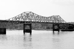
This post card from 1969 shows a portion on the Rock Island Resort near the Great Falls Dam. Of particular interest is the Collins River Bridge in the background.

Collins River Bridge near Rock Island

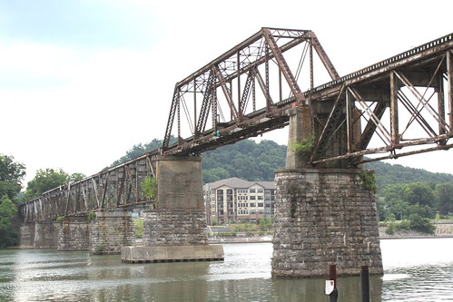
The largest truss on this bridge was originally erected in 1887-1889 as part of the Hyde’s Ferry Bridge located in Davidson County. Eugene Falconnet designed the bridge, and the Mount Vernon Bridge Company erected it. In 1917 Davidson County awarded a contract to the Nashville Bridge Company to relocate two spans from the Hyde’s Ferry Bridge and gave this span to the Nashville Bridge Company. The Nashville Bridge Company stored it until 1924 when the company erected it at this site. Arthur Dyer, president of the Nashville Bridge Company, often used this bridge as an example of the superiority of truss bridges over concrete due to their mobility.

This bridge is located near the 1916 Great Falls Dam, a major power source in the area. In 1922, That dam was raised 35 feet and the bridge which had been located here had to be replaced to accomidate the higher water level. Consequently, the Nashville Bridge Company removed the existing truss bridge from this site in 1924 and erected a new bridge using the stored truss from the Hydes Ferry Bridge.

TVA maintained responsibility for this bridge from the 1930s when they took over the nearby dam until 1982 when the road became state highway TN287. In 1986, a new two-lane bridge was completed parallel to this one and TDOT converted this one into a pedestrian bridge. From there, ownership was transferred to the TN Department of Conservation so that the bridge would be part of a nature trail at Rock Island State Park. Today, the bridge is off limits as both sides are fenced off and the park is hoping to someday raise funds to refurbish the historic bridge for future pedestrian use.

Technical details of the bridge are found in the book "Tennessee's Survey Report for Historic Highway Bridges" where this is entry #112: "Top chords and end posts are channels with lacing, and diagonals and the bottom chords are paired rectilinear eyebars. Verticals are channels with lacing except hip verticals which are paired rectilinear eyerods. Counters are single rectilinear tie rods. The bottom chords are below the floor beams, a somewhat unusual arrangement. The other spans are a 200-foot pin-connected Parker through truss, two 75-foot riveted Warren pony trusses, and three 20-foot steel I-beam approaches. The bridge has a curb-to-curb width of 15 feet and an out-to-out width of 17 feet. The substructure is concrete. Composition of the members of the 1924 trusses is typical. The Parker’s top chords and end posts are channels with lacing. Bottom chords, diagonals and counters are angles with battens. Verticals are paired angles with lacing. The Warrens’ top chords are channels, and the end posts are channels with battens. Bottom chords, verticals, and diagonals are angles with battens."

Wednesday, February 17, 2021

Kyle's Ford Bridge

Kyle's Ford Bridge

This Warren through truss bridge with Polygonal top chords opened in 1930 but was partially demolished in the 2010's. It is also known as Edward R. Talley Bridge and used to carry highway TN70 (Trail of the Lonesome Pine) over the Clinch River in Hancock County, TN. When TDOT built the replacement bridge, they left the old approach so we could still walk up to it. It was also repainted and appears green in older photos. Another spot to get a good view is the back deck at the River Place.

Kyle's Ford Bridge

Wednesday, January 20, 2021

Hernando DeSoto Bridge at Dawn - Memphis

Hernando DeSoto Bridge at Dusk - Memphis

This iconic bridge carries Interstate 40 over the Mississippi river near downtown Memphis, TN. Built in 1973, this two span steel through arch bridge has a total length of 1.8 miles. The length of the bridge covered by the arches is 1800 feet. This view is taken from Tom Lee Park.

Tuesday, January 5, 2021

Cordell Hull Bridge (2014 reopened) driving view - Carthage, TN

Cordell Hull Bridge (2014 reopened) driving view - Carthage, TN

Originally Built in 1936 and recently reopened, the Cordell Hull Bridge crosses the Cumberland River in Carthage, TN.

Work on the bridge began in 1934 and is named after the former US Secretary of State Cordell Hull who lived in the area. The bridge is a 3 span continuous truss at a length of 1412 ft. with the main span over the river at 316 ft. The southwest side of the bridge reaches highway US70N which runs along a bluff near the river. The northwest side intersects with Main St. near the city's central business district. The bridge was added to the National Register of Historic Places in 2009.

The bridge was closed in 2007 when a routine TDOT inspection found the superstructure was in critical condition. Repairs began in August 2011 and they replaced all of the concrete bridge deck and guard rails. The remaining truss, lattice work and rivets were preserved with blast cleaning and then painted white. (It had been green.) The bridge reopened on July 2, 2014.

Wednesday, November 25, 2020

Clinch River Bridge - Clinton, TN

Clinch River Bridge - Clinton, TN

This 1939 bridge by Bethlehem Steel Co. carries highway US25W over the Clinch River in Anderson County, TN. It is believed to be the only Continuous Warren Camelback Through Truss in the state.

Update: This bridge is now scheduled for replacement and demolition by TDOT, although I don't know the timetable.

Wednesday, October 28, 2020

Hernando de Soto Bridge

Hernando de Soto Bridge

The Hernando de Soto Bridge carries Interstate 40 across the Mississippi River and connects Memphis and Arkansas. The through arch bridge opened in 1973 and is a total of 9,432 feet including where it crosses Ark floodplains.

en.wikipedia.org/wiki/Hernando_de_Soto_Bridge

Thursday, October 22, 2020

Bob Sheehan Memorial Bridge - Nashville, TN

Bob Sheehan Memorial Bridge - Nashville, TN

Over the years, I have had several opportunities to photograph old truss bridges that have been converted to pedestrian-only for preservation. This is one of the rare bridges that I have driven over when it was still open for cars in the Donelson neighborhood of Nashville.

When this bridge was originally built in 1928, it carried both directions of traffic along Lebanon Pike (US70) in Nashville. It is a riveted 8-panel Parker through truss with K-Hybrid panels with a total length of 525 ft. to cross the Stones River.

When Lebanon Pike needed to expand to two lanes in both directions, the Elmer Disspayne Sr Memorial Bridge was built parallel to this one to carry two eastbound lanes while the old bridge would carry two westbound lanes. Then when this bridge was structurally deficient in 2009 the Disspayne bridge was widened to carry all the lanes of traffic and this became part of the Stones River Greenway.

Using the historical Google streetview feature, you can get some good before and after views here:
www.google.com/maps/@36.1864483,-86.6330898,3a,75y,251.36...

Monday, October 12, 2020

SeeMidTN slideshow: Top Covered Bridges of Tennessee


Here is a list of all of the best covered bridges in Tennessee.
1) Doe River Bridge in Elizabethton
2) Bible Bridge of Greene County
3) Harrisburg Bridge near Sevierville
4) Parks Bridge in Trimble
5) Emerts Cove Bridge near Gatlinburg
6) Port Royal Bridge remains
7) Red Boiling Springs
8) David Crockett State Park
9) Cumberland Gap rails-to-trails bridge
...and more!

Thursday, August 20, 2020

Clarkson Covered Bridge - Near Cullman, AL

Clarkson Covered Bridge

From Wikipedia:
en.wikipedia.org/wiki/Clarkson%E2%80%93Legg_Covered_Bridge

The Clarkson–Legg Covered Bridge, more simply known as Clarkson Covered Bridge, is a county-owned wooden covered bridge that spans Crooked Creek in Cullman County, Alabama, United States. It is located at Clarkson Covered Bridge Park on County Road 1043 (CR 1043) off U.S. Route 278 near the community of Bethel, about 8 miles (13 km) west of Cullman.

Originally built in 1904, the 270-foot (82-meter) bridge (although some other sources say the bridge is only 250 feet long, including NRHP) is a Town Lattice truss construction over four spans. The Clarkson–Legg Covered Bridge was listed on the National Register of Historic Places on June 25, 1974. It is currently the second-longest existing covered bridge in Alabama and one of the longest in the United States. The bridge is maintained by the Cullman County Commission.

The Clarkson–Legg Covered Bridge was constructed over Crooked Creek in 1904 on property owned by local mail carrier James W. Legg at the cost of $1,500. It was originally named the Legg Covered Bridge after the landowner, who saw the need for transportation improvement in the area and even supplied much of the materials. A flood destroyed half of the bridge in 1921. Most of the pieces were recovered downstream, and the bridge was able to be rebuilt the following year, with help from a contractor hired by Cullman County, also at a cost of $1,500. The covered bridge remained in service to motor traffic until 1962, when it was bypassed by a nearby concrete bridge. As part of the American Bicentennial Project, the Clarkson–Legg Covered Bridge was restored by the Cullman County Commission in 1975, along with a gristmill and log cabin also located at Clarkson Covered Bridge Park. A number of activities are now held at the park, including an annual event by the county called Old-Fashioned Days.

On Christmas Day of 2015, many of the paths and walkways within Clarkson Covered Bridge Park were damaged due to flooding after 8 inches (20 cm) of rain fell in a 24-hour period. The covered bridge itself was unharmed. Although the flood was not as significant as the one which occurred in 1921, it did require the park to be closed to the public while repairs were made. The park reopened on January 13, 2016.

Clarkson Covered Bridge northwest end

Clarkson Covered Bridge inside

Clarkson Covered Bridge (alt view)

Tuesday, July 14, 2020

Oostanaula River Bridge with the Love Locks - Rome, GA

Oostanaula River Bridge - Rome, GA

Originally, this swing Warren through truss bridge was built in 1905 by American Bridge Company so the Central of Georgia Railway could cross the Oostanaula River in Rome, GA. After the train line was abandoned, it became a rails-to-trails project and is now part of the Heritage Park Trail renamed as the Robert Redden Footbridge.

Oostanaula River Bridge - Rome, GA

This pedestrian bridge is now famous for the "Love Locks." To display their undying love, a couple etched their name on a padlock and attached it to the bridge. A few other couples did the same thing and by Valentines Day 2014, the idea had gone viral. Today, the bridge has hundreds of these 'love locks." Read more from the local newspaper article: www.northwestgeorgianews.com/rome/lifestyles/local/local-...

Love Locks of the Robert Redden Bridge - Rome, GA

Saturday, June 6, 2020

O'Neal Bridge - The Shoals, AL

O'Neal Bridge - The Shoals, AL (Southern Bluff View)

O'Neal Bridge - The Shoals, AL (Close-up View)

The O'Neal Bridge was built in 1939 to connect automobile traffic between Florence, Al on the north side to Sheffield and Muscle Shoals on the south side. The 2,071 ft. Cantilevered Warren through truss designed bridge crosses the Tennessee River. Highways US43 and US72 use the bridge that connects Lauderdale and Colbert Counties. The bridge was named in honor of Alabama's Father & Son governors Edward A. O'Neal and Emmett O'Neal.

When originally designing the bridge, engineers knew the southern side is on a bluff, and the northern side would need to be raised for the deck to be level. Dirt was excavated from the area to the west of bridge site on the north shore to form a hill, and the resulting empty space became Florence Harbor.

Also, when the bridge was originally completed, there was a pedestrian lane in the middle. The sidewalk leading to the bridge proceeded down a ramp under the bridge, which then ramped back up to an area between the lanes to the walkway. This walking lane was removed in the 80's during a lane widening project, but the access ramp is still there in the south end, although locked.

O'Neal Bridge - The Shoals, AL (North Shore View) O'Neal Bridge - The Shoals, AL (View from Car)

O'Neal Bridge - The Shoals, AL (B/W view from Old Railroad Bridge) O'Neal Bridge - The Shoals, AL (Florence Harbor View)