Home     Daily Blog     Galleries     Maps     Contact

Showing posts with label Rock Island. Show all posts

Tuesday, March 23, 2021

Post Card Tuesday: Rock Island Resort


This post card from 1969 shows a portion on the Rock Island Resort near the Great Falls Dam. Of particular interest is the Collins River Bridge in the background.

Collins River Bridge near Rock Island

The largest truss on this bridge was originally erected in 1887-1889 as part of the Hyde’s Ferry Bridge located in Davidson County. Eugene Falconnet designed the bridge, and the Mount Vernon Bridge Company erected it. In 1917 Davidson County awarded a contract to the Nashville Bridge Company to relocate two spans from the Hyde’s Ferry Bridge and gave this span to the Nashville Bridge Company. The Nashville Bridge Company stored it until 1924 when the company erected it at this site. Arthur Dyer, president of the Nashville Bridge Company, often used this bridge as an example of the superiority of truss bridges over concrete due to their mobility.

This bridge is located near the 1916 Great Falls Dam, a major power source in the area. In 1922, That dam was raised 35 feet and the bridge which had been located here had to be replaced to accomidate the higher water level. Consequently, the Nashville Bridge Company removed the existing truss bridge from this site in 1924 and erected a new bridge using the stored truss from the Hydes Ferry Bridge.

TVA maintained responsibility for this bridge from the 1930s when they took over the nearby dam until 1982 when the road became state highway TN287. In 1986, a new two-lane bridge was completed parallel to this one and TDOT converted this one into a pedestrian bridge. From there, ownership was transferred to the TN Department of Conservation so that the bridge would be part of a nature trail at Rock Island State Park. Today, the bridge is off limits as both sides are fenced off and the park is hoping to someday raise funds to refurbish the historic bridge for future pedestrian use.

Technical details of the bridge are found in the book "Tennessee's Survey Report for Historic Highway Bridges" where this is entry #112: "Top chords and end posts are channels with lacing, and diagonals and the bottom chords are paired rectilinear eyebars. Verticals are channels with lacing except hip verticals which are paired rectilinear eyerods. Counters are single rectilinear tie rods. The bottom chords are below the floor beams, a somewhat unusual arrangement. The other spans are a 200-foot pin-connected Parker through truss, two 75-foot riveted Warren pony trusses, and three 20-foot steel I-beam approaches. The bridge has a curb-to-curb width of 15 feet and an out-to-out width of 17 feet. The substructure is concrete. Composition of the members of the 1924 trusses is typical. The Parker’s top chords and end posts are channels with lacing. Bottom chords, diagonals and counters are angles with battens. Verticals are paired angles with lacing. The Warrens’ top chords are channels, and the end posts are channels with battens. Bottom chords, verticals, and diagonals are angles with battens."

Monday, September 19, 2016

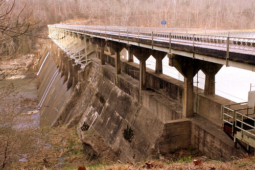
Great Falls Dam and Bridge - Rock Island, TN

Great Falls Dam and Bridge - Rock Island, TN

Great Falls Dam is a hydroelectric dam on the Caney Fork, straddling the county line between White County and Warren County. It is the only dam outside the Tennessee River watershed owned and operated by TVA. The dam impounds the Great Falls Lake, and its tailwaters feed into Center Hill Lake. The completion of Great Falls Dam in 1917 was an engineering triumph, marking the first successful attempt to impound the volatile and flood-prone Caney Fork. The dam is also notable for its design, utilizing a mostly underground conduit to carry water from the reservoir via a tributary to the Power House 0.75 miles (1.21 km) downstream from the dam. The dam and its tailwaters are surrounded by Rock Island State Park.

The bridge was first built in 1925. The first time I ever saw it was in 2004. It was still open then but closed soon afterward. It was the first wood surface bridge I ever drove over, and boy was I nervous! At the time, the bridge was also one way, but I'm not sure if it was always like that. Today, the dam and bridge are listed on the National Register of Historic Places.

In 1994, this dam and bridge was a filming location for the movie "The Specialist" starring Sylvester Stallone and James Woods. It is featured prominently in the opening scene of the movie as the their two characters are supposed to blow up the bridge while a Colombian drug lord is driving over it.I guess the movie producers felt it looked like something from a third world nation! Someone has uploaded this segment of the film to youtube in case you're interested, but keep in mind it's from an R-Rated movie.
www.youtube.com/watch?v=tM0i5atnJc4

Great Falls Dam Bridge - Rock Island, TN

Saturday, December 26, 2015

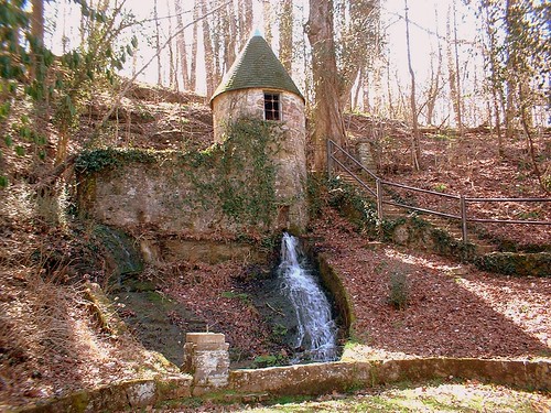
Spring House at Rock Island State Park

at Rock Island State Park

Here at Rock Island State Park, there is a spring that comes out of the side of the mountain. If I remember correctly, this spring house didn't really serve a function and was built like this just for the looks. I once read somewhere that it had a name like the "Witches' Castle" but I can find where I read that. There are stairs leading up to it on the right, but now there is a fence you can't get around. Before that, one could at least look inside. It is across the street from the Great Falls Cotton Mill.

Friday, November 6, 2015

In the News: Ten in Tenn: Great Falls Cotton Mill - Rock Island, TN

A few days ago, the Tennessee Preservation Trust released their 2015 list of endangered historical sites in the state. This week on the blog, we are talking about some of the properties on this list. Here is how TPT describes the list:
"The Tennessee Preservation Trust’s Ten in Tennessee Endangered Properties List Program is TPT’s strongest advocacy tool for the state’s most endangered historic sites. Each year, TPT seeks nominations for the “Ten in Tenn” from the public from each of Tennessee’s nine Development Districts."

You can also see past entries on their website here:
http://www.tennesseepreservationtrust.org/ten-in-tn/?ref=archive

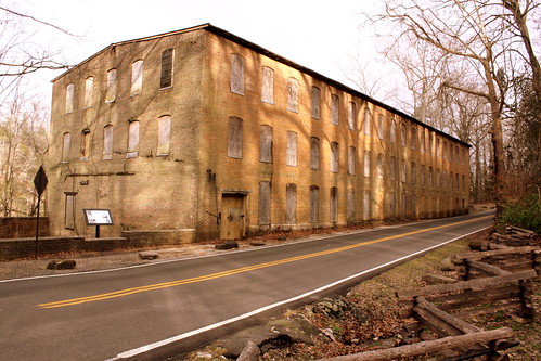
Falls City Cotton Mill - Rock Island, TN

This abandoned mill is located inside of Rock Island State Park along highway TN287 right near the parking lot to view the great falls. Here's the story according to the historical marker:

Falls City Cotton Mill was built in 1892 by Asa Faulkner and several partners. It was the only textile mill in Warren County prior to 1930. The mill was in operation until the great flood of 1902, which destroyed many of the mills in the region. Situated on the bluff above the Great Falls of the Caney Fork River, the structure survived but was forced to close due to the loss of the turbine that washed away.

The Mill was operated by a flume, turbine, ropes, and pulleys powered by water diverted from the falls. The operation included the manufacture of cotton, wood products, and was well known for its heavy cotton sheeting.

Mr. Faulkner, wanting to help those most in need, hired and housed some 300 workers, predominantly widows and children. This created a booming "city" that included a blacksmith, post office, farm, market, and store of company products.

The building has been used for storage for the last 50 years and deterioration over the last 20 has compromised the building’s integrity. Owned by the Tennessee Valley Authority, the building is leased to the Tennessee Department of Environment & Conservation for use by Rock Island State Park. However, bureaucracy, cost of repairs and lack of a vision plan has left the landmark to deteriorate.

Monday, November 4, 2013

Hungry snail

Hungry snail

Snail munching on some greenery.
seen at Rock Island state park, TN

Thursday, July 18, 2013

A portion of Great Falls at Rock Island

a portion of Great Falls

At Rock Island State Park, the widest cataract waterfall in TN works it's way over and around bedrock slabs along a 750 foot segment of the Caney Fork River resulting in multiple falls. This is a segment of the area and falls about 20 feet. From the parking lot, a trail leads below and one can crawl and splash around, depending on the recent rainfall. This was called Horseshoe Falls in the 1800s.

Sunday, May 19, 2013

Rock Island, TN Train Depot

Rock Island Train Depot

Upon my last visit to the town of Rock Island in 2008, I saw how the old NCStL Train Depot was used as a private residence. Today, the depot has been converted into a small antique store. I suppose all of the new decorations to the depot make it visually more interesting. (Make sure you notice the Caboose mailbox on the left.)

2008 Version:
Rock Island, TN Depot (2008)


Sunday, April 28, 2013

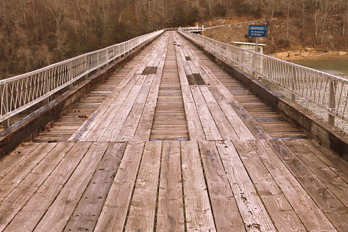
Collins River Bridge near Rock Island

Collins River Bridge near Rock Island

The largest truss on this bridge was originally erected in 1887-1889 as part of the Hyde’s Ferry Bridge located in Davidson County. Eugene Falconnet designed the bridge, and the Mount Vernon Bridge Company erected it. In 1917 Davidson County awarded a contract to the Nashville Bridge Company to relocate two spans from the Hyde’s Ferry Bridge and gave this span to the Nashville Bridge Company. The Nashville Bridge Company stored it until 1924 when the company erected it at this site. Arthur Dyer, president of the Nashville Bridge Company, often used this bridge as an example of the superiority of truss bridges over concrete due to their mobility.

This bridge is located near the 1916 Great Falls Dam, a major power source in the area. In 1922, That dam was raised 35 feet and the bridge which had been located here had to be replaced to accommodate the higher water level. Consequently, the Nashville Bridge Company removed the existing truss bridge from this site in 1924 and erected a new bridge using the stored truss from the Hydes Ferry Bridge.

TVA maintained responsibility for this bridge from the 1930s when they took over the nearby dam until 1982 when the road became state highway TN287. In 1986, a new two-lane bridge was completed parallel to this one and TDOT converted this one into a pedestrian bridge. From there, ownership was transferred to the TN Department of Conservation so that the bridge would be part of a nature trail at Rock Island State Park. Today, the bridge is off limits as both sides are fenced off and the park is hoping to someday raise funds to refurbish the historic bridge for future pedestrian use.

Technical details of the bridge are found in the book "Tennessee's Survey Report for Historic Highway Bridges" where this is entry #112:
"Top chords and end posts are channels with lacing, and diagonals and the bottom chords are paired rectilinear eyebars. Verticals are channels with lacing except hip verticals which are paired rectilinear eyerods. Counters are single rectilinear tie rods. The bottom chords are below the floor beams, a somewhat unusual arrangement. The other spans are a 200-foot pin-connected Parker through truss, two 75-foot riveted Warren pony trusses, and three 20-foot steel I-beam approaches. The bridge has a curb-to-curb width of 15 feet and an out-to-out width of 17 feet. The substructure is concrete. Composition of the members of the 1924 trusses is typical. The Parker’s top chords and end posts are channels with lacing. Bottom chords, diagonals and counters are angles with battens. Verticals are paired angles with lacing. The Warrens’ top chords are channels, and the end posts are channels with battens. Bottom chords, verticals, and diagonals are angles with battens."
Collins River Bridge near Rock Island

Wednesday, January 2, 2013

Rock Island Railroad Bridge

Train Bridge

Train bridge over the Caney Fork River which is on the border of Warren and White county. At this spot, the street forms a bridge over the tracks creating this vantage point. The tracks are live and today used by the short line Caney Fork & Western Railroad.

Sunday, February 13, 2011

Bonus waterfall at Rock Island

Bonus waterfall at Rock Island

We went to Rock Island the day after a heavy rain. As we crawled to the areas where people can play in the water, we walked past this spot where water was pouring out of the side of earth.

Monday, December 27, 2010

Rock Island Train Depot

Rock Island Depot

Train Tracks are still present (I'm practically on them to take this picture) but I'm not sure if trains run these tracks anymore. According to the owner of the antique store in the background, this small depot has been converted into a small apartment. Located on TN287.

Here's an old photo of the depot before it was repainted. This photo was posted to flickr by Kenton Dickerson.
www.flickr.com/photos/27742813@N03/2631009632/

Thursday, September 2, 2010

Twin Falls at Rock Island

Twin Falls 1

Rock Island was already a scenic location, and home to the Great Falls when a dam was added to the Caney Fork River in 1916. Although the waterfall you see here is not man-made, it is the direct result of human action, and is nature's response.

The creation of the Great Falls Dam, caused the Caney Fork and nearby Collins River to rise. This unexpectadly caused water from the Collins River to dig through the rock (perhaps helped by caves that were already there) to form this waterfall.

This "leak" now turns into a 65-to-80 foot segmented cataract. There were early attempts by engineers to plug the hole, but then leaks developed elsewhere. Then, the engineers decided to leave it as is, but still monitor the area to make sure the hill won't collapse.

Rock Island was opened as a Tennessee State Park in 1969, and this area is easily accessible by car. (However, the sign pointing to the area seems to be missing often.)

Wednesday, May 5, 2010

Twin Falls at Rock Island

Twin Falls 3 - Closeup

Rock Island was already a scenic location, and home to the Great Falls when a dam was added to the Caney Fork River in 1916. Although the waterfall you see here is not man-made, it is the direct result of human action, and is nature's response.

The creation of the Great Falls Dam, caused the Caney Fork and nearby Collins River to rise. This unexpectadly caused water from the Collins River to dig through the rock (perhaps helped by caves that were already there) to form this waterfall.

This "leak" now turns into a 65-to-80 foot segmented cataract. There were early attempts by engineers to plug the hole, but then leaks developed elsewhere. Then, the engineers decided to leave it as is, but still monitor the area to make sure the hill won't collapse.

Rock Island was opened as a Tennessee State Park in 1969, and this area is easily accessible by car. (However, the sign pointing to the area seems to be missing often.)

Tuesday, February 16, 2010

Twin Falls at Rock Island

Twin Falls 2

Rock Island was already a scenic location, and home to the Great Falls when a dam was added to the Caney Fork River in 1916. Although the waterfall you see here is not man-made, it is the direct result of human action, and is nature's response.

The creation of the Great Falls Dam, caused the Caney Fork and nearby Collins River to rise. This unexpectadly caused water from the Collins River to dig through the rock (perhaps helped by caves that were already there) to form this waterfall.

This "leak" now turns into a 65-to-80 foot segmented cataract. There were early attempts by engineers to plug the hole, but then leaks developed elsewhere. Then, the engineers decided to leave it as is, but still monitor the area to make sure the hill won't collapse.

Rock Island was opened as a Tennessee State Park in 1969, and this area is easily accessible by car. (However, the sign pointing to the area seems to be missing often.)

Saturday, January 2, 2010

Great Falls at Rock Island

Great Falls

At Rock Island State Park, the widest cataract waterfall in TN works it's way over and around bedrock slabs along a 750 foot segment of the Caney Fork River. This is a segment of the area and falls about 20 feet. This view comes from an observation area from the parking lot, however a trail leads below and one can crawl and splash around, depending on the recent rainfall. This was called Horseshoe Falls in the 1800s.