Home     Daily Blog     Galleries     Maps     Contact

Showing posts with label Scott County. Show all posts

Wednesday, August 4, 2021

O&W Bridge - Big South Fork

O&W Bridge - Big South Fork

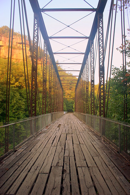
The Oneida & Western Railroad ran from Oneida, TN westward to Jamestown. The primary goal was to haul coal. Despite being a short line, the railroad had many difficult gorges and hollows to navigate. One such construction project was the bridge you see here, which crosses the Big South Fork of the Cumberland River, at a picturesque spot of river rapids. This bridge is a Whipple Through truss built by the Nashville Bridge Co. and placed here in 1915

Railroad Travel was officially abandoned along the line in 1953. Later on, much of the area was encompassed by the Big South Fork National River and Recreation Area and Eventually this bridge became more easily accessible. To get here, start in Oneida and head west. Specifically find O&W road, which out of town becomes a 6 mile long gravel road that is the old O&W railroad bed. The NPS converted this bridge into something you can drive over. With its nice wooden planks, it was scary enough to walk across as it creaks under your feet and you can see the gaps in the wood. I couldn't imagine driving over it, but a few SUVs and trucks did in the hour I was here.

Tuesday, December 29, 2015

O&W Bridge - Big South Fork

O&W Bridge - Big South Fork

The Oneida & Western Railroad ran from Oneida, TN westward to Jamestown. The primary goal was to haul coal. Despite being a short line, the railroad had many difficult gorges and hollows to navigate. One such construction project was the bridge you see here, which crosses the Big South Fork of the Cumberland River, at a picturesque spot of river rapids. This bridge is a Whipple Through truss built by the Nashville Bridge Co. and placed here in 1915

Railroad Travel was officially abandoned along the line in 1953. Later on, much of the area was encompassed by the Big South Fork National River and Recreation Area and Eventually this bridge became more easily accessible. To get here, start in Oneida and head west. Specifically find O&W road, which out of town becomes a 6 mile long gravel road that is the old O&W railroad bed. The National Park Service converted this bridge into something you can drive over. With its nice wooden planks, it was scary enough to walk across as it creaks under your feet and you can see the gaps in the wood. I couldn't imagine driving over it, but a few SUVs and trucks did in the hour I was here.

Finally, here's a link to a video of the area:
mms.nps.gov/ram/ser/grogefly.wmv

Sunday, August 5, 2012

O&W Bridge - Big South Fork (black & white)

O&W Bridge - Big South Fork (black & white)

The Oneida & Western Railroad ran from Oneida, TN westward to Jamestown. The primary goal was to haul coal. Despite being a short line, the railroad had many difficult gorges and hollows to navigate. One such construction project was the bridge you see here, which crosses the Big South Fork of the Cumberland River, at a picturesque spot of river rapids. This bridge is a Whipple Through truss built by the Nashville Bridge Co. and placed here in 1915

Railroad Travel was officially abandoned along the line in 1953. Later on, much of the area was encompassed by the Big South Fork National River and Recreation Area and Eventually this bridge became more easily accessible. To get here, start in Oneida and head west. Specifically find O&W road, which out of town becomes a 6 mile long gravel road that is the old O&W railroad bed. The NPS converted this bridge into something you can drive over. With its nice wooden planks, it was scary enough to walk across as it creaks under your feet and you can see the gaps in the wood. I couldn;t imagine driving over it, but a few SUVs and trucks did in the hour I was here.

Finally, here's a link to a video of the area:
mms.nps.gov/ram/ser/grogefly.wmv

Monday, May 21, 2012

Rock City is Beautiful Beyond Belief

Rock City is Beautiful Beyond Belief

If you've looked through my photostream, you'll see lots of Rock City Barns! I have books, I have maps, I have charts, I have notes from the time I've looked on the Internet to find out where all these barns are. And yet, I missed it. Oh, I was looking for it. I just missed it.

It was about 6 years ago, and my wife and I went out towards Cumberland Falls in hopes of catching the famed Moonbow, and along the way. My gracious wife humors me on these trips as we take a way-out-of-the-way route often with the hope of finding barns. With a dozen or so plotted, we made our trip. Sadly, it's not unusual to miss one. The books are a few years old and some have been torn down right before I got there and others have been razed since the day I was there. If I don't see it, I just assume it's gone for good, and go along my merry way.

Sometimes, it's hidden. For instance, I might look in the right place, but the wrong direction. I thought this one had been gone for good, like so many along the ever-expanding US27 tend to be. Then one day, one of my flickr friends uploaded their picture of the barn, and then it had been in the back of my mind for the next four years as I needed to go look again.

It's one of those areas that far away enough that it stretches the limit of what a day trip can accomplish, but too close to make a vacation out of. I picked a Saturday near the longest day of the year and made my way out there. And I missed it. Again. Thus, I began to wonder if I just wasn't meant to see this one. Of course, I turned around and couldn't miss it.

It's located in Scott County, TN along US27 near Winfield, TN about a mile south of the Kentucky border. As you can see here, there's a lot of greenery surrounding it. To my recollection, it's the only one I've seen with the message the Rock City is Beautiful Beyond Belief.

Thursday, December 29, 2011

Old Scott County Jail - Huntsville, TN

Old Scott County Jail - Huntsville, TN

This historic jail built in 1907 is on the National Register of Historic Places and is located on the other side of a parking lot from the county courthouse. The crenelated wall is made by five by four by three foot blocks of local red sandstone. The jailers quarters are on the first floor. Maximum security prisoners are on the third floor, which was added in 1922.

A replacement jail was built in 1963. Later after a few prisoners escaped, this building was renovated to be the jail again. No prisoners had ever escaped, which is what you would expect from this place, which has the appearance of an impenetrable fortress.

This jail did finally close down in late 2008 with the building of a modern Justice Center a couple of miles away. In the mean time, the city isn't sure what to do with their historic structure. At the time of the closing, it was the second oldest county jail in use (after the Bledsoe Co. Jail in Pikeville). For more info: www.knoxnews.com/news/2008/jul/27/historic-scott-co-jail-...

I saw a picture of this jail from the late 70s. Since then, the front awning has been added, but back then they still had a soda machine out front.

Sunday, August 21, 2011

Huntsville, TN Town Spring

Huntsville, TN Town Spring

Whenever I visit any small town large enough to have a town square, I usually get out of my car and walk around for a while. Usually, I have a mental list of the buildings I want to see and photograph, but I walk around long enough that I make sure there is nothing important I missed. Every once in a while you find something you don't expect to see in the central business district of a city.

Huntsville is a small town, but is large enough to be the county seat of Scott County. A short boulevard leads to the courthouse, with various important buildings surrounding it. Behind the courthouse is a parking lot, and behind that is a small park with a picnic table and an sign with an arrow pointing to the town spring, which I decided to check out.

Normally, when I think of a spring that a town has centered around, I think of the Tennessee cities of Jamestown or Greeneville where water bubbles out of the ground. However, as I walked down the large concrete stairs, I was pleasantly surprised to see a 10 foot tall waterfall. There's enough water flowing here that you could expect a small creek to be the source of the water here, but apparently the water is underground before it gets to this point. Then, the water flows out to become a small tributary of the New River. It's a nice cool spot on a hot summer day.