Home     Daily Blog     Galleries     Maps     Contact

Showing posts with label Sewanee. Show all posts

Wednesday, April 20, 2022

Big Rock & Scenic Overlook - Sewanee, TN

Big Rock & Scenic Overlook - Sewanee, TN

In the earliest days of cross country automobile travel, there weren't as many places to pull over and rest, so the early highway departments would add scenic stops with several parking spaces and concrete picnic tables. This would be even more important for the winding drive up a mountain, especially if it was a new or scary experience.

One of the earliest routes to ascend the Cumberland Plateau in the Monteagle area connected Sewanee at the top to Cowan down below. As the members of the Dixie Highway Association were looking for the best route to cross the plateau, they decided to reuse this early road, making improvements along the incline.

A more detailed description of this spot comes from the TDOT book Tennessee's Survey Report for Historic Highway Bridges on Page 125:
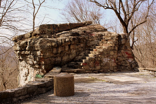
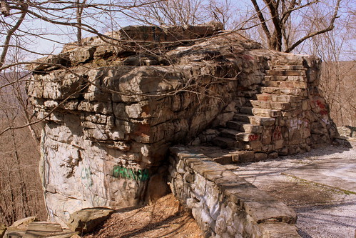
During the 1920s and 1930s, there was a growing interest nationally in scenic beautification projects along highways. These often included turnouts, or pull-offs, sometimes with small parks or picnic areas. If an impressive view existed, the turnout was called a scenic overlook. During the 1930s, beginning in 1934 in Tennessee, federal relief programs funded “Roadside Development,” “Landscaping,” and “Beautification” projects resulting in landscaping projects and a variety of roadside parks, pull-offs or turnouts, and overlooks. An example is the scenic overlook on the steep western side of Monteagle Mountain. In 1918 Franklin County issued a $300,000 bond issue for road improvements which included a joint project with the state in 1919 to improve a ten mile stretch of the Dixie Highway through the county that contained this pull-off. It is unknown if the original pull-off, which contained a sweeping 400 foot stone wall flanking a massive boulder, pre-dates the 1919 project or if it was built (or enhanced) as part of the project. In 1936 the state spent $11,190 as a National Recovery Highway Project to landscape 5.4 miles of the Cowan to Sewanee section of State Route 15 (the Dixie Highway). The 1936 project, whose plans show the location of the original stone wall, removed the older wall and erected a new wall of rubble masonry 1400 feet long, cut steps into the boulder (7” rise, 12” tread, and 30” width), and paved the parking area with macadam stone. The state also built over 900 discontiguous feet of rubble masonry walls and planted over 2100 trees and shrubbery “grouped in as natural arrangements as possible” on the project.

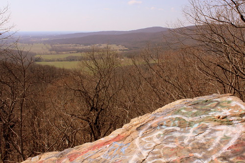
While the road was originally part of the Dixie Highway, and then state route TN15, eventually it became US41A/US64. (It is not US64 anymore as that route now meets I-24 and ascends Monteagle that way.) This area is right along the western edge of the Domain of the University of the South. The stone masonry that extends from the left of the boulder eventually meets up with the highway marking the western entrance of the University of the South. When you climb up the steps, you see the surface of the boulder is covered with graffiti covering graffiti. My personal favorite was "Don't fall of and die!!!" (Things dating back to the Thirties don't always have guardrails.) Even still, in the 10 minutes I was here, multiple carloads of young and old passengers stopped for family portraits.

Tuesday, February 23, 2021

Post Card Tuesday: Sewanee Natural Bridge 1943


From Wikipedia:
Sewanee Natural Bridge in Franklin County, Tennessee, is a 25 feet (8 m) high natural sandstone arch with a span of 50 feet (15 m). It is essentially a giant sinkhole partially eroded to form a large stone bridge. A wet weather spring located behind the bridge in a rock cave probably contributed to the erosion forming the arch. It is called the Sewanee Natural Bridge as it was once owned by the University of the South in Sewanee, Tennessee. It is a 3 acre (12,000 m²) designated state natural area.

Today, the Area is considered part of the South Cumberland State Park. You can't get to the bottom if you are afraid of heights as you have to walk over the bridge, which is about 3 ft. wide, to get to the other side where you can scale down it. To get here, you'd follow the signs off highway TN56. Here's a picture from 2010:

Sewanee Natural Bridge

Thursday, March 30, 2017

Big Rock & Scenic Overlook - Sewanee, TN

Big Rock & Scenic Overlook - Sewanee, TN

In the earliest days of cross country automobile travel, there weren't as many places to pull over and rest, so the early highway departments would add scenic stops with several parking spaces and concrete picnic tables. This would be even more important for the winding drive up a mountain, especially if it was a new or scary experience.

One of the earliest routes to ascend the Cumberland Plateau in the Monteagle area connected Sewanee at the top to Cowan down below. As the members of the Dixie Highway Association were looking for the best route to cross the plateau, they decided to reuse this early road, making improvements along the incline.

A more detailed description of this spot comes from the TDOT book Tennessee's Survey Report for Historic Highway Bridges on Page 125:
During the 1920s and 1930s, there was a growing interest nationally in scenic beautification projects along highways. These often included turnouts, or pull-offs, sometimes with small parks or picnic areas. If an impressive view existed, the turnout was called a scenic overlook. During the 1930s, beginning in 1934 in Tennessee, federal relief programs funded “Roadside Development,” “Landscaping,” and “Beautification” projects resulting in landscaping projects and a variety of roadside parks, pull-offs or turnouts, and overlooks. An example is the scenic overlook on the steep western side of Monteagle Mountain. In 1918 Franklin County issued a $300,000 bond issue for road improvements which included a joint project with the state in 1919 to improve a ten mile stretch of the Dixie Highway through the county that contained this pull-off. It is unknown if the original pull-off, which contained a sweeping 400 foot stone wall flanking a massive boulder, pre-dates the 1919 project or if it was built (or enhanced) as part of the project. In 1936 the state spent $11,190 as a National Recovery Highway Project to landscape 5.4 miles of the Cowan to Sewanee section of State Route 15 (the Dixie Highway). The 1936 project, whose plans show the location of the original stone wall, removed the older wall and erected a new wall of rubble masonry 1400 feet long, cut steps into the boulder (7” rise, 12” tread, and 30” width), and paved the parking area with macadam stone. The state also built over 900 discontiguous feet of rubble masonry walls and planted over 2100 trees and shrubbery “grouped in as natural arrangements as possible” on the project.

While the road was originally part of the Dixie Highway, and then state route TN15, eventually it became US41A/US64. (It is not US64 anymore as that route now meets I-24 and ascends Monteagle that way.) This area is right along the western edge of the Domain of the University of the South. The stone masonry that extends from the left of the boulder eventually meets up with the highway marking the western entrance of the University of the South. When you climb up the steps, you see the surface of the boulder is covered with graffiti covering graffiti. My personal favorite was "Don't fall of and die!!!" (Things dating back to the Thirties don't always have guardrails.) Even still, in the 10 minutes I was here, multiple carloads of young and old passengers stopped for family portraits.

Thursday, February 25, 2016

Big Rock & Scenic Overlook - Sewanee, TN

Big Rock & Scenic Overlook - Sewanee, TN

In the earliest days of cross country automobile travel, there weren't as many places to pull over and rest, so the early highway departments would add scenic stops with several parking spaces and concrete picnic tables. This would be even more important for the winding drive up a mountain, especially if it was a new or scary experience.

One of the earliest routes to ascend the Cumberland Plateau in the Monteagle area connected Sewanee at the top to Cowan down below. As the members of the Dixie Highway Association were looking for the best route to cross the plateau, they decided to reuse this early road, making improvements along the incline.

A more detailed description of this spot comes from the TDOT book Tennessee's Survey Report for Historic Highway Bridges on Page 125:
During the 1920s and 1930s, there was a growing interest nationally in scenic beautification projects along highways. These often included turnouts, or pull-offs, sometimes with small parks or picnic areas. If an impressive view existed, the turnout was called a scenic overlook. During the 1930s, beginning in 1934 in Tennessee, federal relief programs funded “Roadside Development,” “Landscaping,” and “Beautification” projects resulting in landscaping projects and a variety of roadside parks, pull-offs or turnouts, and overlooks. An example is the scenic overlook on the steep western side of Monteagle Mountain. In 1918 Franklin County issued a $300,000 bond issue for road improvements which included a joint project with the state in 1919 to improve a ten mile stretch of the Dixie Highway through the county that contained this pull-off. It is unknown if the original pull-off, which contained a sweeping 400 foot stone wall flanking a massive boulder, pre-dates the 1919 project or if it was built (or enhanced) as part of the project. In 1936 the state spent $11,190 as a National Recovery Highway Project to landscape 5.4 miles of the Cowan to Sewanee section of State Route 15 (the Dixie Highway). The 1936 project, whose plans show the location of the original stone wall, removed the older wall and erected a new wall of rubble masonry 1400 feet long, cut steps into the boulder (7” rise, 12” tread, and 30” width), and paved the parking area with macadam stone. The state also built over 900 discontiguous feet of rubble masonry walls and planted over 2100 trees and shrubbery “grouped in as natural arrangements as possible” on the project.

While the road was originally part of the Dixie Highway, and then state route TN15, eventually it became US41A/US64. (It is not US64 anymore as that route now meets I-24 and ascends Monteagle that way.) This area is right along the western edge of the Domain of the University of the South. The stone masonry that extends from the left of the boulder eventually meets up with the highway marking the western entrance of the University of the South. When you climb up the steps, you see the surface of the boulder is covered with graffiti covering graffiti. My personal favorite was "Don't fall of and die!!!" (Things dating back to the Thirties don't always have guardrails.) Even still, in the 10 minutes I was here, multiple carloads of young and old passengers stopped for family portraits.
Thursday, November 27, 2014

Sewanee Memorial Cross - Happy Thanksgiving!

Sewanee Memorial Cross

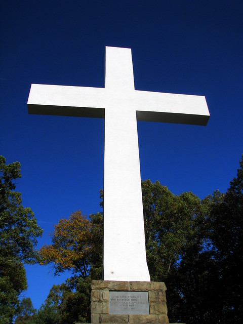
This is the approx. 60 ft. tall Memorial Cross on the campus of University of the South in Sewanee, TN. The cross was built in 1922 in honor of war veterans and is near the edge of a western bluff of the mountain, where you can see it for miles away.

Thursday, June 13, 2013

Templeton Library - Sewanee, TN

Templeton Library - Sewanee, TN

The Templeton Library in Sewanee was built to be a philanthropic endeavor by John Templeton. He was an important and influential businessman and stock market investor who lived in the area. The Library never actually had any books here and it was converted into condominiums. (Draw your own conclusions.)

Templeton Library - Sewanee, TN

The notable thing about this building to me is it's what you see if you're driving from Cowan to Sewanee. There's a long straight drive along US41A right before the ascent up the mountain and the back of this building is at the top of the hill here. This is what it looks like from behind.

Friday, October 28, 2011

Sewanee Natural Bridge

Sewanee Natural Bridge

From Wikipedia:

Sewanee Natural Bridge in Franklin County, Tennessee, is a 25 feet (8 m) high natural sandstone arch with a span of 50 feet (15 m). It is essentially a giant sinkhole partially eroded to form a large stone bridge. A wet weather spring located behind the bridge in a rock cave probably contributed to the erosion forming the arch. It is called the Sewanee Natural Bridge as it was once owned by the University of the South in Sewanee, Tennessee. It is a 3 acre (12,000 m²) designated state natural area.

Today, the Area is considered part of the South Cumberland State Park. You can't get to the bottom if you are afraid of heights as you have to walk over the bridge, which is about 3 ft. wide, to get to the other side where you can scale down it. To get here, you'd follow the signs iff highway TN56.

Monday, August 22, 2011

Sewanee Natural Bridge

Sewanee Natural Bridge

From Wikipedia:
Sewanee Natural Bridge in Franklin County, Tennessee, is a 25 feet (8 m) high natural sandstone arch with a span of 50 feet (15 m). It is essentially a giant sinkhole partially eroded to form a large stone bridge. A wet weather spring located behind the bridge in a rock cave probably contributed to the erosion forming the arch. It is called the Sewanee Natural Bridge as it was once owned by the University of the South in Sewanee, Tennessee. It is a 3 acre (12,000 m²) designated state natural area.

Today, the Area is considered part of the South Cumberland State Park. You can't get to the bottom if you are afraid of heights as you have to walk over the bridge, which is about 3 ft. wide, to get to the other side where you can scale down it. To get here, you'd follow the signs off highway TN56.

Sunday, June 19, 2011

All Saints' Chapel - Sewanee, TN

All Saints' Chapel

When the University of the South was first established in Sewanee, TN, plans were setup to eventually have a campus chapel.

Half a century passed until the foundation was laid for the Gothic chapel made of Tennessee Sandstone. Walls were built and a temporary roof was added so that chapel could be used in 1910. The permanent roof wasn't finally completed until 1957.

The tower on the right is a carillon tower, known as the Shapard Tower. The tower was donated to the school as a gift by the Shapard Family. The largest bell weighs 7,500 lbs.

Sunday, April 24, 2011

Sewanee Memorial Cross

Sewanee Memorial Cross

This is the approx. 60 ft. tall Memorial Cross on the campus of University of the South in Sewanee, TN. The cross was built in 1922 in honor of war veterans and is near the edge of a western bluff of the mountain, where you can see it for miles away.

Saturday, February 19, 2011

Otey Parish - Sewanee, TN

Otey Parish - Sewanee, TN

It's not the most famous church on the University of the South campus, but it's still a fine looking one on this autmn day. This Episcopal Building was built in 1891 and named in honor of the first Episcopal Bishop in Tennessee

Thursday, December 23, 2010

Sewanee Natural Bridge

Sewanee Natural Bridge

From Wikipedia:

Sewanee Natural Bridge in Franklin County, Tennessee, is a 25 feet (8 m) high natural sandstone arch with a span of 50 feet (15 m). It is essentially a giant sinkhole partially eroded to form a large stone bridge. A wet weather spring located behind the bridge in a rock cave probably contributed to the erosion forming the arch. It is called the Sewanee Natural Bridge as it was once owned by the University of the South in Sewanee, Tennessee. It is a 3 acre (12,000 m²) designated state natural area.

Today, the Area is considered part of the South Cumberland State Park. You can't get to the bottom if you are afraid of heights as you have to walk over the bridge, which is about 3 ft. wide, to get to the other side where you can scale down it. To get here, you'd follow the signs iff highway TN56.

Wednesday, September 29, 2010

Sewanee Memorial Cross

Sewanee Memorial Cross

This is the approx. 60 ft. tall Memorial Cross on the campus of University of the South in Sewanee, TN. The cross was built in 1922 in honor of war veterans and is near the edge of a western bluff of the mountain, where you can see it for miles away.