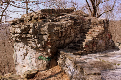
In the earliest days of cross country automobile travel, there weren't as many places to pull over and rest, so the early highway departments would add scenic stops with several parking spaces and concrete picnic tables. This would be even more important for the winding drive up a mountain, especially if it was a new or scary experience.
One of the earliest routes to ascend the Cumberland Plateau in the Monteagle area connected Sewanee at the top to Cowan down below. As the members of the Dixie Highway Association were looking for the best route to cross the plateau, they decided to reuse this early road, making improvements along the incline.
A more detailed description of this spot comes from the TDOT book Tennessee's Survey Report for Historic Highway Bridges on Page 125:
During the 1920s and 1930s, there was a growing interest nationally in scenic beautification projects along highways. These often included turnouts, or pull-offs, sometimes with small parks or picnic areas. If an impressive view existed, the turnout was called a scenic overlook. During the 1930s, beginning in 1934 in Tennessee, federal relief programs funded “Roadside Development,” “Landscaping,” and “Beautification” projects resulting in landscaping projects and a variety of roadside parks, pull-offs or turnouts, and overlooks. An example is the scenic overlook on the steep western side of Monteagle Mountain. In 1918 Franklin County issued a $300,000 bond issue for road improvements which included a joint project with the state in 1919 to improve a ten mile stretch of the Dixie Highway through the county that contained this pull-off. It is unknown if the original pull-off, which contained a sweeping 400 foot stone wall flanking a massive boulder, pre-dates the 1919 project or if it was built (or enhanced) as part of the project. In 1936 the state spent $11,190 as a National Recovery Highway Project to landscape 5.4 miles of the Cowan to Sewanee section of State Route 15 (the Dixie Highway). The 1936 project, whose plans show the location of the original stone wall, removed the older wall and erected a new wall of rubble masonry 1400 feet long, cut steps into the boulder (7” rise, 12” tread, and 30” width), and paved the parking area with macadam stone. The state also built over 900 discontiguous feet of rubble masonry walls and planted over 2100 trees and shrubbery “grouped in as natural arrangements as possible” on the project.
While the road was originally part of the Dixie Highway, and then state route TN15, eventually it became US41A/US64. (It is not US64 anymore as that route now meets I-24 and ascends Monteagle that way.) This area is right along the western edge of the Domain of the University of the South. The stone masonry that extends from the left of the boulder eventually meets up with the highway marking the western entrance of the University of the South. When you climb up the steps, you see the surface of the boulder is covered with graffiti covering graffiti. My personal favorite was "Don't fall of and die!!!" (Things dating back to the Thirties don't always have guardrails.) Even still, in the 10 minutes I was here, multiple carloads of young and old passengers stopped for family portraits.
No comments:
Post a Comment