Home     Daily Blog     Galleries     Maps     Contact

Showing posts with label marker. Show all posts

Wednesday, November 11, 2020

Tennessee Zero Milestone

Tennessee Zero Milestone

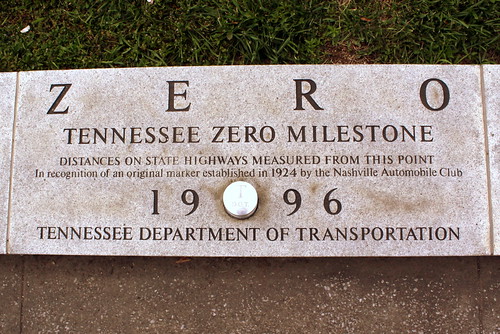
When you're on the highway and it says that Nashville is 37 miles away, it means you are 37 miles from this marker, which notes, "Distances on state highways measured from this point." TDOT placed this marker at Bicentennial Mall State Park when it opened in 1996.

The original Zero Milestone was placed om May 12, 1924 at the corner of Union Street and Sixth Ave. in Downtown. Later it was relocated in front of the highway department's new building on Charlotte Ave. Later, a new TDOT building was built and this multi-ton stone was misplaced. The new zero milestone seen here was added to the park after an extensive search for the original yielded no results.

Saturday, August 26, 2017

Stewart County Iron Industry marker

Stewart County Iron Industry marker

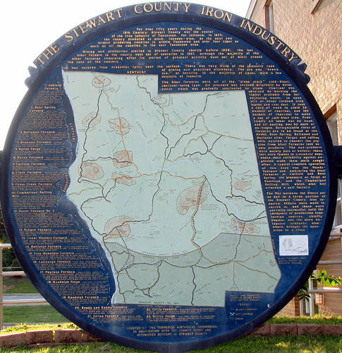
This quite thorough marker is located at the Stewart County Courthouse in Dover, TN.
You'll need to pull up the photo in original size if you want to attempt to read it. It's a map of the entire county and where to find all of the historic iron furnaces.

Thursday, August 25, 2016

Judge Allison / Dixie Highway Marker

Judge Allison / Dixie Highway Marker

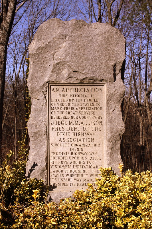
In the earliest days of American Highways, before there was the numbered route system of today, there were National Auto Trails. One of the most prominent of these trails was the Dixie Highway where the western branch connected Chicago and Miami. The first and only president of the Dixie Highway Association was judge M. M. Allison of Chattanooga. The original route through the area involved building a road up and down Walden's Ridge in the Suck Creek area, a project that lasted from about 1919-24. Since this area atop Walden's Ridge was the highest point along the Dixie Highway as well as vaguely the midpoint between Chicago and Miami, the Association decided to build a small roadside park here as well as this monument which was dedicated in 1924.

An editorial discussing the event in the Atlanta Constitution by editor Clark Howell, one of Georgia’s two directors on the Dixie Highway Association, said, “No man in the south has contributed more to the development of the south--indeed the whole country for it is a national project-- than Judge Allison in his faithful and untiring work in this one outstanding interstate highway project”

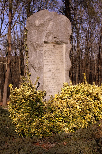
The text of the marker, which still stands, states: "This memorial is erected by the people of the United States to mark their appreciation of the great service rendered our country by Judge M. M.Allison, president of the Dixie Highway Association since its organization in 1915. The Dixie Highway was founded upon his faith, his hope and his far vision, his indefatigable labor throughout the states wherein it winds its useful way made possible its realization."

With all of the hairpin turns and difficult terrain to navigate, an alternate and more popular route between Jasper and Chattanooga was soon developed, which today is highway US41. In other words, the original Dixie Highway marker was essentially bypassed for a more convenient route, however this small pullover and monument is still there today as the road is now state highway TN27.

Judge Allison / Dixie Highway Marker

Wednesday, August 3, 2016

Pulaski's Square Mile Marker

Pulaski's Square Mile Marker

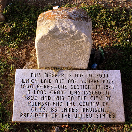
A few years ago when I was driving through Pulaski and heading north of town along highway US 31A, I saw a green "Historical Marker" sign next to an empty gravel lot. I pulled into the gravel lot and I didn't see anything historical anywhere around. Then after a couple of minutes I saw this at the base of that green "historical marker" sign. It's easy to miss. It reads:

This marker is one of four which laid out one square mile (640 acres=one section) in 1841. A land grant was issued in 1809 and 1813 to the city of Pulaski and the county of Giles, by James Madison, President of the United States.

Sunday, July 31, 2016

Jellico, TN Stone Marker

Jellico, TN Stone Marker

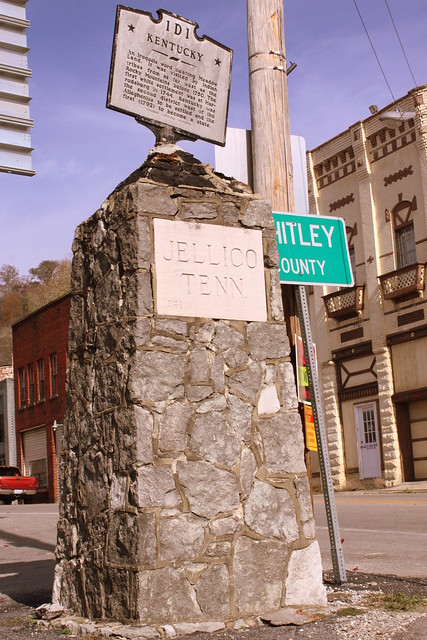
The city limits for Jellico, TN also happens to be the state line. Kentucky is on the other side of this marker along US25W. The stone marker has "Jellico Tenn" on both sides, as well as the date 1941. Since then, the historic marker has been added to the top. The historic marker tells you what you are entering, which is Kentucky if you're going this way or Campbell County from the other side.

Thursday, August 6, 2015

Geographic Center of Tennessee monument

Geographic Center of Tennessee monument

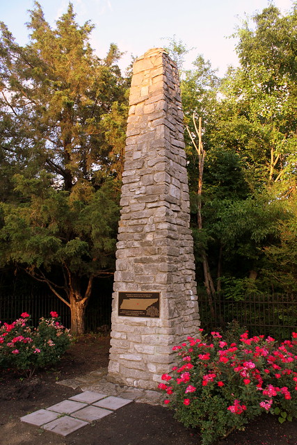
The first time I visited this spot was in 2008 and it looks a lot better now. I'm not sure how they picked the exact spot, but it was convenient that an important highway ran right next to it. When this was originally built it was in the middle of nowhere but the area around it is fully developed now. It is located along Old Lascassas Pike as the newer highway TN96 runs parallel to this street

In 2008, the metal marker was stolen, but was replaced a year or two later. Landscaping has also improved around the area.

Text of the marker:
This marker is erected at a point designated as the Geographical Center of the state of Tennessee. Erected in 1978 by the Rutherford County Historical Society. It memorializes the 200th year of American Independence. This area has been under the jurisdiction of England, Mero district of N. Carolina, Davidson County, State of Franklin, Territory South of the River Ohio & the State of Tennessee

Saturday, March 28, 2015

Confederate Marker - Colliersville, TN

Confederate Marker - Colliersville, TN

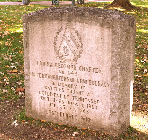
This marker placed by the Louisa Bedford Chapter of the United Daughters of the Confederacy was placed in the park in the middle of Colliersville's town square.

Monday, January 5, 2015

Geographic Center of Tennessee monument

Geographic Center of Tennessee monument

The first time I visited this spot was in 2008 and it looks a lot better now. I'm not sure how they picked the exact spot, but it was convenient that an important highway ran right next to it. When this was originally built it was in the middle of nowhere but the area around it is fully developed now. It is located along Old Lascassas Pike as the newer highway TN96 runs parallel to this street

In 2008, the metal marker was stolen, but was replaced a year or two later. Landscaping has also improved around the area.

Text of the marker:
This marker is erected at a point designated as the Geographical Center of the state of Tennessee. Erected in 1978 by the Rutherford County Historical Society. It memorializes the 200th year of American Independence. This area has been under the jurisdiction of England, Mero district of N. Carolina, Davidson County, State of Franklin, Territory South of the River Ohio & the State of Tennessee

Saturday, June 14, 2014

Hawkins County Lee Highway Milestone Marker

Hawkins County Lee Highway Milestone Marker

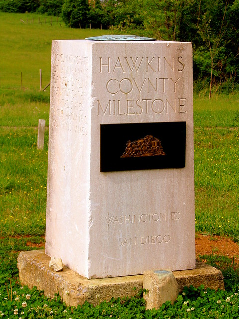
Back in the earliest days of highways before the routes had numbers, the most important auto trails had names and one of the most important cross country route was the Lee Highway which connected Washington DC to San Diego. In many places along the Lee Highway (and at five places in Tennessee), there were Zero Milestone markers such as the one here. With such a marker, brochures and other place of interest could say how far they were from the zero milestone to help motorists find them. Few of these markers 90 year old markers still exist as they are obsolete as there are newer ways to mark distance, roadway expansion and widening cause them to be removed, and sometimes they are stolen as people wish to have a piece of roadside history.

Fortunately, the Hawkins County marker still exists as it is located on the east side of Rogersville at another obsolete highway feature, the Roadside Park. On the front of the marker is a plaque depicting an old stagecoach wagon. This marker had been stolen but was recently replaced. The small stone in front of it is a common USGS Benchmark from 1934. On the top of the marker is a copper compass. On the east side are the words: "To Commemorate John Carter, Sturdy pioneer, first merchant, after whom this valley is named." On the back, it says "This monument marks the route of the old East Tennessee Stagecoach line 1825-1855." On the west side, it says "To Commemorate Benjamin Hawkins of North Carolina, Senator of the United States, after whom this county is named."

Wednesday, April 3, 2013

Tri-State Spot in the News: Tennessee, Georgia and Alabama

Tri-State Spot in the News: Tennessee, Georgia and Alabama

In the United States, there are 62 spots where 3 or more states meet at a single point, 38 of which are on land. Of these 38, perhaps none of them have made as much news over the last several years as the spot where Tennessee, Georgia and Alabama all meet.

In 1796, the U.S. congress established the border between Tennessee and Georgia to run along the longitude of the 35th Parallel. In 1926, Georgia hired Mathematician and University professor James Camak to mark the spot where the three states came together. After he performed all of his calculations, he placed a colorful stone at the site he had measured (and the stone was later dubbed the Camak Stone). As it turns out, he missed it by a mile. While it wasn't what the Congress decreed, it still became the official border location. If there was a TV show called "Surveyors Biggest Bloopers" perhaps this would make the opening segment.

Fast forward about 180 years and people weren't laughing any more. The state of Georgia was going through a drought and Atlanta area gardens started to get thirsty. That's when somebody remembered part of their state had been sliced off. As it turns out, if the Camak Stone had been placed where it ought to have been, a smidgen of the Tennessee River, and more importantly the Nickajack Lake impoundment would be in Georgia. Someone daydreamed of getting a siphon as wide as the Keystone Pipeline and all of Georgia's water consumption needs would be fixed. All they would need is to stick a pipe about 500 feet across the border and the crisis would be resolved. Georgia asked politely and Tennessee said "No." From there, it is presumed that someone got angry and wanted revenge because the really old Camak Stone was stolen in 2007. We can only assume at the motivation because there's no evidence whodunit. In March of 2011, the marker seen in this photo was placed to replace the stolen stone from a few years earlier.

Fast forward again to March 25, 2013 where the Georgia state senate voted 48-2 to take what they think is rightfully theirs. Instead of asking for everything south of the 35th, they're looking to add about one and a half square miles of land, or a small notch to get to the precious life-giving water. Again, Tennessee said "Nickajack is ours, and you can't have it!" They also noted it would be unfair for the people who live in this area to have to start paying GA income tax while also speculating the Peach State might steal the whole river when nobody's looking. Alabama refuses to take a position in the matter, but they already have all the Tennessee River they need.

As it turns out, I hadn't been paying attention to the news when three days later I was in the mood to visit the tri-state spot. I didn't see any tanks or infantry ready to defend their territory in the area. To get here, the street turns a corner around State Line Cemetery and there's a place for a car to park on the side of the road. From here, there's a small opening in the trees that begins the path through the woods. The walk is about 300 feet up the side of a mountain where I was thankful it wasn't a mile climb up the mountain. From here, you could even see the lake. I was thinking that if Georgia's border did change, Alabama's wouldn't and this would still be the three state spot, but the marker would still have to be changed. Maybe someday I can have a before-and-after comparison. Still, State Line Cemetery's name would have to be changed.

Tri-State Spot in the News: Tennessee, Georgia and Alabama

Saturday, March 16, 2013

Sam Davis Executed here

Sam Davis Executed here

The Boy Hero of the Confederacy was executed at this spot in Pulaski, TN on Nov 27, 1863. A small museum was erected near this spot. This area of town is now listed on the National Register of Historic Places as the Sam Davis Avenue Historic District.

Friday, July 1, 2011

Geographic Center of Tennessee

Monument to something

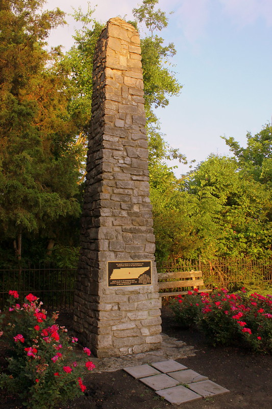
As of the time this photo was taken, there was no explanation about what we're looking at here. It really is the marker for the geographic center of Tennessee, which is conveniently located just off a major highway. The area now is a fully developed resedential area and this tiny park has no sign, enough parking for about 3 cars, one park bench and an old Iron fence around the small property. This is located in Murfreesboro on old TN96, Old Lascassas Pike and not very far from MTSU.

After I originally posted this photo, I got this note from someone with the screen name Wimpy:

So, from what I gather in my 30+ years here in the boro is that if you ever want to leave murfreesboro and never come back (due to the Murfreesboro Curse that says that if you buy anything from Davis Market youll never leave murfreesboro) you have to do one of these two things: pee on this monument or stand on your head and kiss it. Sounds like some locals are really just setting alot of people up for a really bad joke. -Wimpy

Then, I got another note from Howard33:

Good news! The plack on the monument has been replaced. I sent an email to the Daily News Journal and they got right on it. Of course there is no way of knowing for sure if my email had anything to do with it, but I choose to believe it did. Anyway there is a picture of the repaired monument in my photostream.
I bought stuff at Davis Market as early as 1953, and I have been gone from there for 50 years. OK, I admit that I go back to Murfreesboro for visits. I graduated from MTSU* in 1958.
*In those days it was MTSC, but who cares?


So, my advice, if you want to see it, do it sooner, rather than later, before someone pries the marker off of it again!

Wednesday, February 9, 2011

Former Capitals of Tennessee markers

To my knowledge, there are three places in Tennessee that have markers commemorating their place as a former state capital.

In 1949, the state government decided to place markers around the state for all the locations where the state capital was located before Nashville.

Knoxville was the first Capital, and here is its marker:

Knoxville, Capital of Tennessee Marker

The side of this marker mentions Gov. Browning and the 76th General Assembly who made it happen.

Marker #2 is in Kingston and I don't have a photo of it available right now. We'll move on to #3

Monument: Murfreesboro as TN State Capital

Murfreesboro was the state Capital from 1818 to 1826.

Thursday, July 29, 2010

Cumberland Mtn Tunnel Marker

Cumberland Mtn Tunnel Marker

A marker in honor of a historically significant tunnel along the railroad from Nashville to Chattanooga. They couldn't go over or around the mountain ridge, so they had to go through it. It's my understanding that this marker used to be at the tunnel, where nobody but train people could see it. Now it is in Cowan, TN, near the depot at the base of the ascent.