The Daily blog of SeeMidTN.com, pictures from Middle Tennessee and nearby cities.
Saturday, January 31, 2015
Friday, January 30, 2015
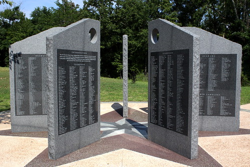
Blythe Ferry Cherokee Removal Memorial
Blythe Ferry was a ferry across the Tennessee River in Meigs County, TN. In 1838, the ferry served as a gathering point and crossing for the Trail of Tears. While the ferry no longer exists, the ferry site is now part of the Cherokee Removal Memorial Park, which was dedicated in 2005.
The Blythe Ferry site is situated along the eastern bank of the Tennessee River, just south of the mouth of the Hiwassee River. The site is located near a point where Meigs County, Rhea County, and Hamilton County meet. Highway TN60, which formerly crossed the river at the ferry, connects the area to Cleveland to the east, Dayton to the west, and Decatur to the north.
At the memorial site is a log cabin which houses the museum and serves as the visitors center. The Cherokee Removal Memorial is seven panels (one for each Cherokee clan) listing the names of each of the 2,537 heads of household forced to relocate. A short walk or drive from the plaza is an observation deck from a bluff overlooking the Ferry site.
for more info: www.cherokeeremoval.org/index.htm
Here is the Blyhte Ferry history on Wikipedia:
Blythe Ferry was established by William Blythe and his Cherokee wife, Nancy Fields, around 1809. The ferry was an important river crossing on the "Great Road" between Chattanooga and Knoxville. Blythe sold the ferry in 1825, and the Blythe family would make the trek west with the Cherokee in the 1830s. In 1836, the Treaty of New Echota was ratified, transferring all Cherokee lands east of the Mississippi River to the United States. The treaty called for a general relocation of the Cherokee Nation to the Indian Territory (modern Oklahoma). In 1838, President Martin Van Buren ordered General Winfield Scott to round up all Cherokees who had not voluntarily made the trek to Oklahoma and commence a forced removal. By the Fall of the that year, some 9000 Cherokee and 300 Creek had been imprisoned in stockades in Bradley County, a few miles to the east. It took several weeks to move the entire contingent across the river, with the last detachment crossing on November 12, 1838. Blythe Ferry operated until the mid-1990s, when a bridge was built spanning the river immediately downstream. The ferry site was placed on the National Register of Historic Places in 1982.
Thursday, January 29, 2015
Wednesday, January 28, 2015
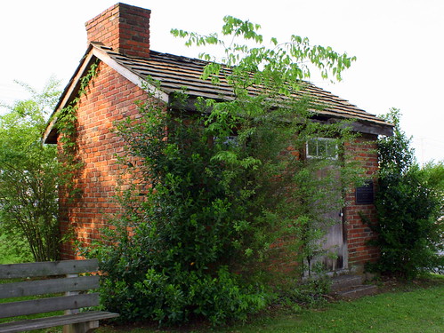
Repica of Andrew Johnson's Tailor Shop - Rutledge, TN
Yesterday, we looked at Johnson's actual tailor shop in Greeneville. Here is a replica of another.
Located on the grounds of the Grainger County Courthouse in Rutledge Tennessee is this brick Replica of President Andrew Johnson's first Tailor Shop. Johnson started out as an indentured apprentice to a tailor in Greeneville, but ran away and started his own practice at this location. The small brick building was shared with the local sheriff for about six months. After Johnson's former employer died, he moved back to Greeneville. The replica was built in 1976.
Labels:
Andrew Johnson,
Grainger County,
Rutledge,
us11,
US11W
Tuesday, January 27, 2015
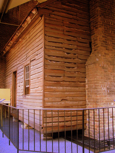
Andrew Johnson's Tailor Shop
Before he was President, Before he was Vice President to Lincoln, Before he was a US Senator, Before he was a US Congressman, before he was Tennessee Governor, before he was a state senator, before he was a state congressman, before he was a mayor of Greeneville, before he was an Alderman, Andrew Johnson started out as a tailor.
This is Andrew Johnson's Tailor shop, and it's located in the heart of Greeneville across the street from his early home. Of course, now there is a building built around it to protect it from the elements. This is now the central part of the visitor's center at the Andrew Johnson National Historic Site.
Tomorrow, we will look at a replica Andrew Johnson Tailor Shop.
Labels:
Andrew Johnson,
Greene County,
Greeneville,
log cabin
Monday, January 26, 2015
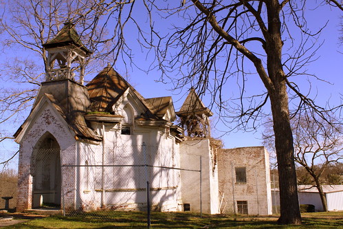
In the news: Historic Mt. Olivet Cemetery Chapel Destroyed by Fire
The historic Mt. Olivet Cemetery Chapel and Office has been destroyed by a fire. The building had been listed as an endangered property for several years as preservationists had been seeking to get it restored for years. The photo above was taken three years ago in 2012.
For the full story, here is an article from the Tennessean.
http://www.tennessean.com/story/news/l.../
The Spam-mobile
Sunday, January 25, 2015
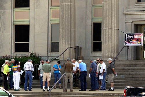
Prayer on the Square - Huntingdon, TN
There used to be a time where I'd go to photograph something like a courthouse and my goal would be to get as little human evidence as possible in the shot. (No people, no cars, etc...) Over the years, what I have come to realize is these buildings are not relics of a bygone era, but an important public meeting place, whether it be for a local festival, political rally or for a religious event as it was on this day. To avoid such things would cause me to miss out on the true spirit of the county.
Saturday, January 24, 2015
Southern Loans neon sign - Kingsport, TN
Friday, January 23, 2015
Vintage Sprite sign at Jones Meat Processing!
Thursday, January 22, 2015
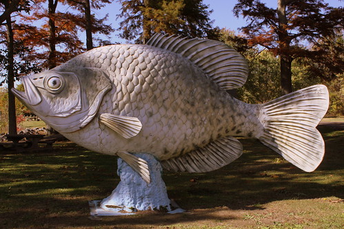
Fiberglass Crappie at Reelfoot Lake
Located at Kirby Pocket at Reelfoot Lake in Obion County is this large fiberglass Crappie. Dating back to the 1970s, it could use a fresh coat of paint.
Labels:
fish,
Obion County,
Reelfoot Lake,
Roadside America
Wednesday, January 21, 2015
Tuesday, January 20, 2015
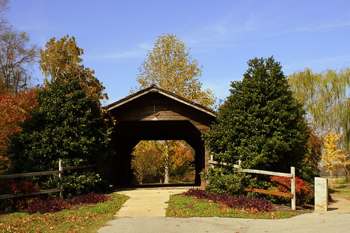
Parks Covered Bridge - Trimble, TN
Obion County farmer Emerson E. Parks built this bridge, the Parks or Trimble Covered Bridge, in 1904 to span a drainage ditch dividing two of his fields on his farm. Although the bridge’s original purpose was agricultural, local traffic also used it until 1928, when the state built a state route with a modern bridge nearby. The bridge remained in use on Trimble's farm until 1997. At that time, due to erosion at the original site that had endangered the historic bridge, the community salvaged as much material as possible and rebuilt the bridge in a city park in Trimble, which resulted in the bridge being delisted from the National Register of Historic Places.
This is what it looked like in 1993: bridgehunter.com/photos/24/68/246838-L.jpg
The wooden bridge is 59 ft. long, 11.4 feet wide, and has 10 ft. of vertical clearance. A gable roof originally covered the bridge, but a tornado destroyed the original roof in 1914. After the tornado, Parks replaced the gable roof with a flat shed roof.
It is one of a small number of Covered bridges in Tennessee. There are also ones in Elizabethton, Sevierville, Lawrenceburg, Red Boiling Springs and Greene County.
Monday, January 19, 2015
Lorraine Hotel Neon Sign - Memphis, TN
As America honors Martin Luther King, Jr. on the third Monday in January, I'd like to share this photo of the National Civil Rights Museum that promotes the vision that Dr. King embraced.
Walter Bailey purchased the Windsor Hotel in 1945 and renamed it the Lorraine Motel. Located close the the center of Memphis, during the days of segregation the motel catered to an upscale black clientele.
In April 1968, King traveled to Memphis in support of striking sanitation workers. King stayed in room 306, located on the second floor of the Lorraine Motel. At 6:01 PM on April 4, 1968 while he was standing on the balcony outside his room, King was struck by a single bullet, causing him to fall backwards unconscious.
Following the assassination, Bailey left Room 306 undisturbed. While the Motel remained open for a few more years, Bailey worked to preserve the motel as a historic site raising funds to Save the Lorraine. The Martin Luther King Memorial Foundation bought the motel in 1982. The Motel officially closed in 1998 as the property transformed into a museum.
For architectural designs, the museum called upon McKissack & McKissack from Nashville, the first African American architecture firm in America. After purchasing adjoining property, the museum opened in Sept. 1991.
Today, on the grounds of the museum, a wreath is placed at the balcony where King was hit. The original sign for the museum has been preserved outside. From this iconic photo from the balcony there are two cars visible below, and there are replicas of these two cars at the museum today. For now, customers of the museum are allowed to look into the window of Room 306.
Sunday, January 18, 2015
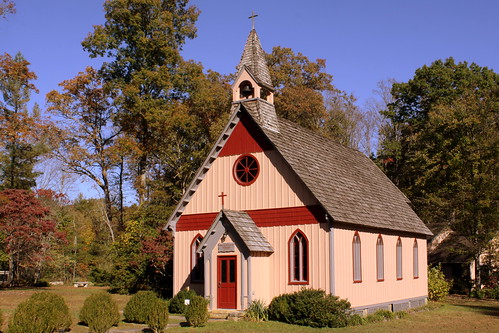
Christ Church Episcopal - Rugby, TN
Rugby is a small community along the Cumberland Plateau in Morgan County, founded by British Immigrants in 1880. The Rugby Colony was designed to be a utopian community, but the design failed in less than a decade. Still a few townspeople and their descendants lived in the area over the next several decades. In the 1960s, residents, friends and descendants of Rugby began restoring the original design and layout of the community, preserving surviving structures and reconstructing others.
The Christ Church Episcopal was established on October 5, 1880, and initially used the original Rugby schoolhouse for services. The current building was built in the Carpenter Gothic style in 1887 by Cornelius Onderdonk, who constructed many of the original buildings in Rugby, and consecrated by Episcopal bishop Charles Quintard in 1888. The church's alms basin was designed by English carpenter Henry Fry, who had previously done work for various churches in the London area. The church's reed organ, built in 1849, is one of the oldest in the United States. The Christ Church congregation has met here regularly since 1887.
Labels:
church,
Cumberland Plateau,
Morgan County,
Rugby,
TN52
Saturday, January 17, 2015
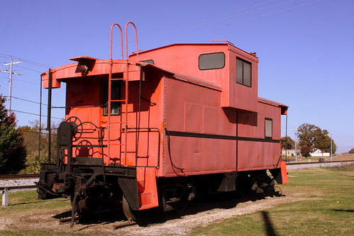
Caboose - Greenfield, TN
Although repainted a solid red color, this caboose was originally from ICG (Illinois Central Gulf Railroad). Although I didn't see the sign, apparently this caboose was dedicated to a couple of teens killed in a car wreck. The caboose is seen along US45E at the center of the town in Weakley County.
Labels:
caboose,
Greenfield,
train,
US45,
US45E,
Weakley County
Friday, January 16, 2015
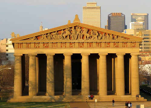
The Parthenon (with some of the Nashville Skyline)
I love taking pictures of the Parthenon and it occurred to me that this was an angle I'd never before seen.
On a personal note, this photo has extra special meaning to me. At the time, my wife was an ICU patient at Centennial Medical Center which is seen along the left of the picture. She nearly died on Feb. 22 2014 but the fine doctors there kept her alive. A month later, she was still in the ICU but not as critical, so I felt comfortable walking around the neighborhood and seeing some of the sights. You can learn more of the experience here:
www.facebook.com/MariLynnIan
Labels:
centennial park,
Nashville,
parthenon,
skyline
Thursday, January 15, 2015
Pappy's Drive-In neon sign - Milan, TN
Labels:
Gibson County,
Milan,
neon,
restaurant,
sign,
US45,
US45E
Wednesday, January 14, 2015
The King's Heartbreak Hotel faded sign - Memphis
Tuesday, January 13, 2015
Monday, January 12, 2015
Sunday, January 11, 2015
Saturday, January 10, 2015
Fading Pepsi Wall ad - Trimble, TN
Friday, January 9, 2015
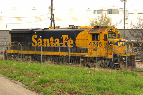
Santa Fe 4245 (Now NWRR)
This old Santa Fe GE B23-7 diesel locomotive is now owned by Nashville & Western Railroad (and previously Nashville & Eastern Railroad. NERR and NWRR are owned by the same people.) I originally say this train parked here from I-40 just west of downtown Nashville so on my next time in the area, I decided to get a closer look.
Thursday, January 8, 2015
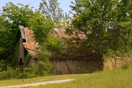
See 7 States from ROCK CITY
atop Lookout Mt.
It wasn't too long ago that this Rock City barn was in much better shape. Here is an older photo of the same barn. If you compare the modern picture with the one on the link, you'll see how small trees are growing in front of this barn and the barn is just in worse shape now. The barn is visible to southbound traffic along highway KY91 about 5 miles north of Princeton, KY in Caldwell County.
See it on a map here: goo.gl/maps/NAAZr
This is now one of 86 different Rock City Barns I have photographed and uploaded to Flickr in my Rock City Barns set. People often ask me how I've found so many of them. I have drawn from many resources such as books and web sites and sometimes luck, but there's not really one "go to" place to find them all. Well, now on my website, I have tried to create a one stop source for the locations of all of the barns I've been to. On my Map of Rock City Barns page, I have plotted each barn on a Google Map.
Wednesday, January 7, 2015
Helms Candy Co. neon sign - Bristol, VA
This building must have been their factory. It was located on the north side of Bristol, VA along the Lee Highway (US11/19).
Helms was formed in 1976 when Jobbers and Loudy candy companies merged. The full history is here: www.helmscandy.com/companypage.html
Tuesday, January 6, 2015
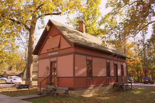
Rugby, TN Printing Works
Rugby is a small community along the Cumberland Plateau in Morgan County, founded by British Immigrants in 1880. The Rugby Colony was designed to be a utopian community, but the design failed in less than a decade. Still a few townspeople and their descendants lived in the area over the next several decades. In the 1960s, residents, friends and descendants of Rugby began restoring the original design and layout of the community, preserving surviving structures and reconstructing others.
The Rugby Print shop is not an original building in Rugby, but since it has a comparable design and similar age it was moved here. The print shop was originally in the nearby town of Deer Lodge in 1887 and was moved here in 1978. for more info: www.historicrugby.org/featured-volunteers-carolyn-and-jul...
Monday, January 5, 2015
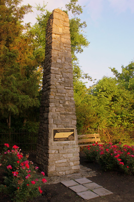
Geographic Center of Tennessee monument
The first time I visited this spot was in 2008 and it looks a lot better now. I'm not sure how they picked the exact spot, but it was convenient that an important highway ran right next to it. When this was originally built it was in the middle of nowhere but the area around it is fully developed now. It is located along Old Lascassas Pike as the newer highway TN96 runs parallel to this street
In 2008, the metal marker was stolen, but was replaced a year or two later. Landscaping has also improved around the area.
Text of the marker:
This marker is erected at a point designated as the Geographical Center of the state of Tennessee. Erected in 1978 by the Rutherford County Historical Society. It memorializes the 200th year of American Independence. This area has been under the jurisdiction of England, Mero district of N. Carolina, Davidson County, State of Franklin, Territory South of the River Ohio & the State of Tennessee
Sunday, January 4, 2015
Saturday, January 3, 2015
Walnut Street Bridge at Night
The Walnut Street Bridge is a Six-span through truss bridge over the Tennessee River on Walnut Street. It opened in 1891 and is a length of 2,370 ft. The bridge was closed to auto traffic in 1978, sat in disrepair for about a decade and then was converted into one of the world's longest pedestrian bridges. Now, the bridge is on the National Register of Historic Places. This photo was taken from the deck of the Delta Queen.
Friday, January 2, 2015
Elliston Place Soda Shop counter
Subscribe to:
Posts (Atom)