The Daily blog of SeeMidTN.com, pictures from Middle Tennessee and nearby cities.
Showing posts with label Duck River. Show all posts
Thursday, September 30, 2021
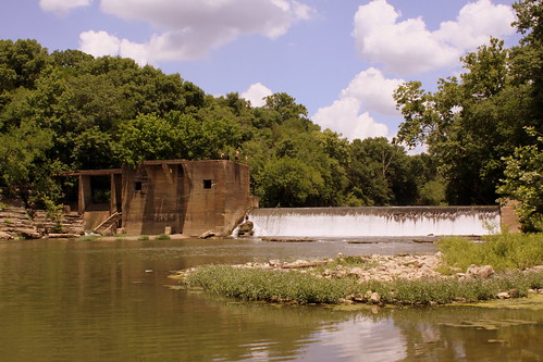
Lillard's Mill Hydroelectric Station
This historic mill on the Duck River is in rural Marshall County, TN and the unincorporated community that was built nearby was known as Milltown. This dam was completed in 1928 and is historically significant as one of three dams on the Duck River to predate TVA. You can read it's entry on the National Register of Historic Places here: npgallery.nps.gov/AssetDetail/NRIS/89002370
Today, the area is considered a park and popular with the locals. To get here, follow there is a gravel driveway that leads off of Milltown Rd. This driveway leads to a parking lot, and you can then walk the gravel to the Duck River. This is a calm spot in the river 1000 ft past the dam, and it is popular for swimming and rafting. To the east, you can walk along the rocky terrain to get a closer view of the dam. If you take a close look, there are some adventurous teens that have climbed onto it.
Thursday, August 12, 2021
Columbia Hydroelectric Station
The construction of the hydroelectric station was completed in 1925. It was designed by Freeland, Roberts and Co. and built by Foster & Creighton for the Southern Cities Corporation. It is one of the remaining hydroelectric stations in Tennessee that predates the TVA. It has been listed on the National Register of Historic Places since February 9, 1990. This view of the dam and the Duck River is easily accessible from Riverwalk Park.
focus.nps.gov/AssetDetail/NRIS/89002364
Sunday, May 10, 2020
Fun on the Duck River - Milltown, TN
This is a wide and shallow area of the Duck River, which makes it a popular location for swimming and kayaking. While I was here, several buses dropped off kayakers who will pick them up somewhere downstream. I took this photo on Memorial Day but am sure it is just as popular on July 4th weekend.
This spot is about 500 feet downstream from Lillard's Mill. There is a gravel lot which can hold about 30 cars off of Milltown Road. It's not too far off of highway TN272 north of Verona in Marshall County.
Saturday, September 3, 2016
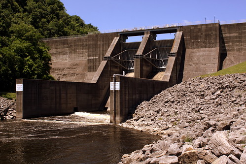
Normandy Dam
Normandy Dam is a dam built by the TVA on the Duck River It straddles the border between Bedford and Coffee counties. It is the TVA's largest dam that does not produce any electricity. It was built in the 1970s for flood control, water supply and recreational uses.
Labels:
Bedford County,
Coffee County,
dam,
Duck River,
Normandy,
TVA
Monday, April 4, 2016
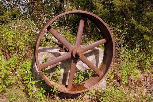
Wilhoite Mill 1902 Wheel
Located along the Duck River in Marshall County was the site of three mills over the years. This wheel was part of the 1902 mill constructed on higher ground after the original was destroyed by a flood. A belt attached to the wheel transferred power from the turbines below to the mill building. A passage for the belt was trenched through the limestone and can still be seen in the area.
Wilhoite was a community that was built up around the area of the mills. Today, all that remains are the building blocks of some of those buildings plus a few pieces of the mills. A trail has been built to access these places. This area is adjacent to and across the river from the main part of Henry Horton State Park along highway US31A.
Saturday, January 18, 2014
May 2010 flood damage: Centerville Bridge
This Bridge was built in 1913 to carry traffic over the Duck River on the west side of Centerville. I think I heard that Minnie Pearl would talk about walking across this bridge as a child.
In 1970, a new bridge was built and Tennessee highway 50 was rerouted across the river causing this one to be closed.
When the huge storms brought over a foot of rainfall in the first weekend of May 2010, floods destroyed this and to my knowledge two other bridges in Middle Tennessee. (the other two are the old bridge at Hurricane Mills and an old Harpeth River bridge on Old Harding Rd in SW Davidson Co.
Labels:
Bridge,
Centerville,
Duck River,
flood,
Hickman County
Saturday, March 2, 2013
Remains of the 1846 Wilhoite Mill
The remains of the original penstock piers can still be seen along the bank of the Duck River in Marshall County. Here, water was diverted to turn two turbines. The mill was rated at 60 barrels of flour and 150 bushels of corn per day. The Mill and a nearby bridge were destroyed by a flood of March 28, 1902, but a newer mill was built higher up along the bank, and some of those remains also survive today.
After the Civil War, a small community sprung up around the mill, which included a general store, a blacksmith, a post office and some housing. Today, little remains of the Wilhoite community other that what is left of the two mills. This can be seen as part of the Wilhoite Mill trail at Henry Horton State Park, and is across the duck river from most of the rest of this park. The entrance to the parking area can be seen along US31A.
Wednesday, February 20, 2013
Old Stone Fort Bridge - Manchester, TN
This Pratt through truss bridge crosses the Duck River at Old Stone Fort State Archaeological Park in Manchester, TN and is used to connect the campground to the main road. The one land bridge with a wooden driving surface was built in 1906 and crossed the Elk River at Dabbs Ford (Which as far as I can tell was about 20 miles away to the southeast). The bridge was relocated here to cross the Duck River in 1971 and was then rehabilitated in 2009. My favorite feature is the etched pattern at the top, as you don't see that too often around here.
Labels:
Bridge,
Coffee County,
Duck River,
Manchester,
Old Stone Fort
Tuesday, January 15, 2013
Duck River Slackwater Navigation Co.
This is one of a series of small murals painted on the side of a building in the middle of Columbia, TN, just a block north of the town square. These murals were painted by local artist Bonnie Callewaert.
I had never heard of this company or Slackwater Navigation in general. The company operated along the Duck River between Columbia and Centerville in the 1840s.
Friday, January 4, 2013
Upper Big Falls - Old Stone Fort
There's an impressive waterfall just to the right of this photo. Unfortunately, there's nowhere to stand to get a good tripod-mounted view of it. I brought my tripod and by golly I was going to use it! 15 feet upstream from the big falls is this rather tiny 3-5 foot waterfall, but it stretches the entire width of the Duck River here.
Labels:
Coffee County,
Duck River,
Manchester,
Old Stone Fort,
waterfall
Wednesday, November 7, 2012
Old Stone Fort Bridge - Manchester, TN
This Pratt through truss bridge crosses the Duck River at Old Stone Fort State Archaeological Park in Manchester, TN and is used to connect the campground to the main road. The one land bridge with a wooden driving surface was built in 1906 and crossed the Elk River at Dabbs Ford (Which as far as I can tell was about 20 miles away to the southeast). The bridge was relocated here in 1971 and rehabilitated in 2009. My favorite feature is the etched pattern at the top, as you don't see that too often around here.
Labels:
Bridge,
Coffee County,
Duck River,
Manchester,
Old Stone Fort
Tuesday, June 21, 2011
Looking through the trestle
This is a section of the massive wooden trestle of the Centerville, TN Railroad Bridge.
You can see through a long segment of the trestle until the end where there is a stone pier for the truss part of the bridge over the Duck River.
Labels:
Bridge,
Centerville,
Duck River,
Hickman County
Wednesday, March 16, 2011
The old Only Bridge
This long unused derelict bridge used to carry highway TN50 across the Duck River near the town of Only, TN in Hickman county. The truss bridge was built by Nashville Bridge Company in 1907 and was rendered obsolete by another bridge right next to it in 1962. The largest span is 225' with a total length of 395'. If this is something you want to see for yourself, this is less than a mile off Interstate 40.
Here's two more views:
Subscribe to:
Posts (Atom)