Home     Daily Blog     Galleries     Maps     Contact

Showing posts with label Monroe County. Show all posts

Thursday, February 3, 2022

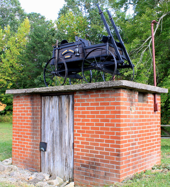
Coker Creek Gold Mining Cart

Coker Creek Gold Mining Cart

There have been gold prospectors in Tennessee. Here is the text of the nearby historic marker:
Placer gold was discovered along Coker Creek in 1831. For a time there was feverish digging; $80,000 of Coker Creek gold was mined between 1831 and 1854. Since then there has been sporadic mining here.

Apparently there is still plenty of panning and dredging along coker creek today. I suppose this cart is a rememberance of the early mining here. This spot at Coker Creek Village is located along TN68 just south og Tellico Plains in Monroe County.

Wednesday, November 18, 2020

Fort Loudoun State Park

Fort Loudoun State Park

From Wikipedia:
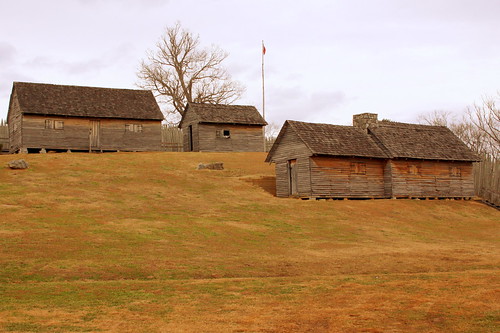
Fort Loudoun was a British colonial-era fort located in what is now Monroe County, Tennessee, United States. Built in 1756 and 1757 to help garner Cherokee support for the British at the outset of the Seven Years' War, the fort was one of the first significant British outposts west of the Appalachian Mountains. The fort was designed by John William G. De Brahm, its construction was supervised by Captain Raymond Demeré, and its garrison was commanded by Demeré's brother, Paul Demeré. It was named for the Earl of Loudoun, the commander of British forces in North America at the time.

Relations between the garrison of Fort Loudoun and the local Cherokee inhabitants were initially cordial, but soured in 1758 due to hostilities between Cherokee fighters and European settlers in Virginia and South Carolina. After the massacre of several Cherokee chiefs who were being held hostage at Fort Prince George, the Cherokee laid siege to Fort Loudoun in March 1760. The fort's garrison held out for several months, but diminishing supplies forced its surrender in August 1760. Hostile Cherokees attacked the fort's garrison as it marched back to South Carolina, killing more than two dozen and taking most of the survivors prisoner.

The fall of Fort Loudoun led to an invasion of Cherokee territory by General James Grant and an important peace expedition to the Overhill country by Henry Timberlake. The fort was reconstructed in the 20th century based on the detailed descriptions of its design by De Brahm and Demeré, and excavations conducted by the Works Progress Administration, the Fort Loudoun Association, and the Tennessee Division of Archaeology. It was designated a National Historic Landmark in 1965, and is now the focus of Fort Loudoun State Park.

Tuesday, June 30, 2020

Tellico Blockhouse site

Tellico Blockhouse site

From Wikipedia:

The Tellico Blockhouse was an early American outpost located along the Little Tennessee River in Vonore, Monroe County, Tennessee. Completed in 1794, the blockhouse operated until 1807 with the purpose of keeping the peace between nearby Overhill Cherokee towns and early Euro-American settlers in the area in the wake of the Cherokee–American wars. The Tellico Blockhouse was the site where several treaties were negotiated in which the Cherokee were induced to cede large portions of land in Tennessee and Georgia. During this period, the blockhouse was the site of official liaisons between the United States government and the Cherokee.

The Tellico Blockhouse site is located at the junction of Nine Mile Creek and the Little Tennessee River (now Tellico Lake), just off U.S. Route 411 between Maryville and Vonore. Fort Loudoun was located just across the river to the west, but was in ruins by the time the blockhouse was built.

For much more history:
en.wikipedia.org/wiki/Tellico_Blockhouse

Tuesday, June 6, 2017

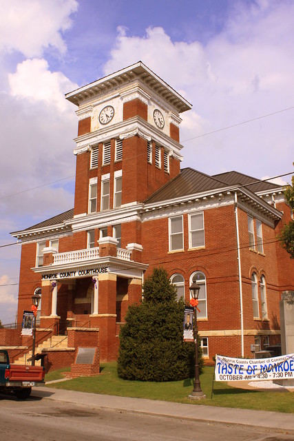
Monroe County Courthouse - Madisonville, TN

Monroe County Courthouse - Madisonville, TN

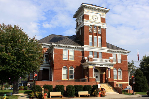
Monroe County's 4th and current courthouse was built in 1897 at a cost of $17,000. At the time, it was praised in the local paper for it's useful functionality and with "no useless ornamentation on the outside." Today, it is listed on the National Register of Historic Places.

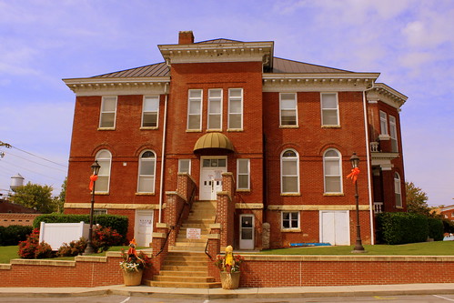
The two story brick building is built upon a high basement features a tall tower over the front entrance. Externally, above the basement level is a stone water table and also a cornice at the eave line of the hipped roof. At the main entrance is a one story porch supported with four square brick columns and topped by a balustrade. The clock tower features square pilasters with Ionic and Doric caps. A rear annex was added to the rear in 1979.

Monroe County Courthouse Rear View - Madisonville, TN

Monday, January 2, 2017

Monroe County Courthouse - Madisonville, TN

Monroe County Courthouse - Madisonville, TN

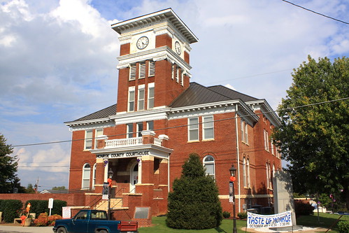
Monroe County's 4th and current courthouse was built in 1897 at a cost of $17,000. At the time, it was praised in the local paper for it's useful functionality and with "no useless ornamentation on the outside." Today, it is listed on the National Register of Historic Places.

The two story brick building is built upon a high basement features a tall tower over the front entrance. Externally, above the basement level is a stone water table and also a cornice at the eave line of the hipped roof. At the main entrance is a one story porch supported with four square brick columns and topped by a balustrade. The clock tower features square pilasters with Ionic and Doric caps. A rear annex was added in 1979.

Friday, July 15, 2016

Monroe County Courthouse - Madisonville, TN

Monroe County Courthouse (Alt) - Madisonville, TN

Monroe County's 4th and current courthouse was built in 1897 at a cost of $17,000. At the time, it was praised in the local paper for it's useful functionality and with "no useless ornamentation on the outside." Today, it is listed on the National Register of Historic Places.

The two story brick building is built upon a high basement features a tall tower over the front entrance. Externally, above the basement level is a stone water table and also a cornice at the eave line of the hipped roof. At the main entrance is a one story porch supported with four square brick columns and topped by a balustrade. The clock tower features square pilasters with Ionic and Doric caps. A rear annex was added to the rear in 1979.

Sunday, September 28, 2014

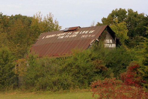
Bible Verse Barn in East Tennessee

Bible Verse Barn in East Tennessee

There are plenty of barns along the old backroads advertising all kinds of products and tourist attractions, but this is the first one I've seen with a Bible verse or two, although I suspect there are plenty more out there. On the roof, it quotes Proverbs 14:30: A sound heart is the life of the flesh. In the front of the barn, the verse is partially obscured, but I'm going to guess it's John 14:15: If ye love me, keep my Commandments. This barn is on Highway TN68 in Monroe County between Tellico Plains and Madisonville.

Tuesday, October 22, 2013

See Rock City: Turn Right on US64

See Rock City: Turn Right on US64

TURN RIGHT ON US64
ROCK CITY GARDENS
ATOP LOOKOUT MTN.

This old Rock City barn with the paint-chipping roof is located along US411 south of Madisonville, TN about halfway to Englewood. It's facing southbound traffic where you'll see it on the left (east) side of the street. From here, US64 is about 30 miles away and that highway will take you all the way to Chattanooga. If you were to stay on the route they suggest, you'd be about two hours away, although if Rock City was your destination, you could save half an hour by taking the Interstate.

This is now one of 82 different Rock City Barns I have photographed and uploaded to Flickr in my Rock City Barns set. People often ask me how I've found so many of them. I have drawn from many resources such as books and web sites and sometimes luck, but there's not really one "go to" place to find them all. Well, now on my website, I have tried to create a one stop source for the locations of all of the barns I've been to. On my Map of Rock City Barns page, I have plotted each barn on a Google Map.

Wednesday, September 25, 2013

Very faded "See Rock City" barn

Very faded "See Rock City" barn

You have to look very closely to see any of the paint. At one time, it said:
SEE
ROCK CITY
World's 8th Wonder

When travelling southbound on US11 from the city of Sweetwater, this old barn is on the left, and this farm land is right next to an Ingles grocery store. This could be some prime real estate, so who knows how much longer this barn will be here. (Of course, I thought the same thing when I first saw it in 2007.)

Monday, July 22, 2013

The Lost Sea - Sweetwater, TN

The Lost Sea - Sweetwater, TN

Craighead Caverns is an extensive cave system located in Sweetwater, Tennessee. It is best known for containing the United States' largest and the world's second largest non-subglacial underground lake, The Lost Sea. In addition to the lake, the caverns contain an abundance of crystal clusters called anthodites, stalactites, stalagmites and a waterfall.

The lake was discovered in 1905 by a thirteen-year-old boy named Ben Sands. As the story goes Sands, who often played in the cave, happened upon a small opening and crawled through. The room was so large he was unable to see the ends of the room with his lantern, so he threw balls of mud in all directions and heard splashes. When he went back home and told people of his discovery they were hesitant to believe him. By the time Ben convinced his father to go back down with him to explore it further, the water level had risen, hiding the cave entrance from them. It was rediscovered by local explorers several years later.

The visible surface of the lake measures 800 feet long and 220 feet wide (4.5 acres) at normal "full" capacity. Cave divers have explored several rooms that are completely filled with water, without reaching the end of the cave. This exploration was conducted in the 1970s.
For many years The Lost Sea was considered the world's largest underground lake and is still recognized as the world's second largest non-subglacial underground lake after Dragon's Breath Cave, Namibia.

Boat tours of the lake are still given and for many people are the highlight of the tour. In times of extreme drought (such as 2007-08) the lake recedes significantly and the management had to extend the walkway and the boat dock in order to be able to provide the boat tours. According to the management of the Lost Sea, the water level in the lake dropped 28 feet below its normal level at the height of the drought. At such times visitors see a much larger cavern above the lake surface.

There are also Rainbow Trout in the lake. They aren't native to the Lost Sea, but were added to the lake decades ago in an attempt to see how big the lake was. (It didn't work.) The tour guide has fish food which is thrown to the trout as part of the tour with the glass bottom boat. These fish have also lost much of their color from being in a cave for so long.
Sunday, January 27, 2013

The Lost Sea - Vintage Moonshine Still

The Lost Sea - Vintage Moonshine Still

Craighead Caverns is an extensive cave system located in Sweetwater, Tennessee. It is best known for containing the United States' largest and the world's second largest non-subglacial underground lake, The Lost Sea. In addition to the lake, the caverns contain an abundance of crystal clusters called anthodites, stalactites, stalagmites and a waterfall.

Decades ago, before the sea at the bottom of the cave was found, there was a bar inside the cave (or Cavern Tavern), with multiple moonshine stills. One of the problems with this is the atmospheric conditions inside a cave counteract the effects of drunkedness and bar patrons would drink more than their usual limit. The lack of sobriety wouldn't be noticed until attempting to climb all of the stairs out of the cave. As our tour guide put it: The higher you get - The higher you get.

Sunday, January 23, 2011

Old Street Sign - Sweetwater, TN

Old Street Sign - Sweetwater, TN

The way street signs used to be! A few of these old markers, such as Main St. at Walnut St., are preserved in downtown Sweetwater, where Main St. is also the Lee Highway and US11.