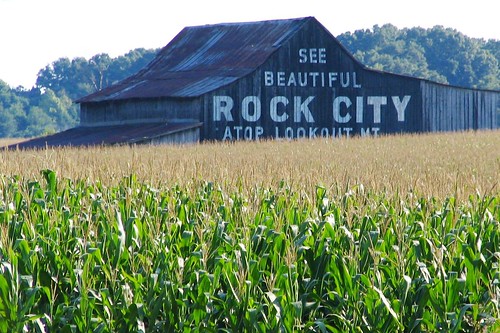
They say you can see 7 states from Rock City. It's a claim that is highly debated, especially by geologists that say the curvature of the earth would prevent seeing Kentucky (or Virginia) across the entire state of Tennessee. This post focuses an unusual state border irregularity between Kentucky and Tennessee and this barn which is just a stones throw away on the Kentucky side.
As you can tell, the primary crop here is corn. If Geddes, KY is on your map, that is where this barn is located. It's in Simpson Co. Ky. on highway U.S. 31W, one of the 2 primary routes from Louisville to Nashville. It's also south of Bowling Green, KY and Franklin, KY. The other side of the farm is lines with trees and on the other side of the trees is Interstate 65. If you were to take I-65 across the border to KY exit #2 and were to drive 1/4 of a mile, you'd be here. This barn is about 1 mile from the Tennessee state line, and if it weren't for an unusual border irregularity it would be closer to only 1/2 a mile from the state border. This border jag has an interesting history of its own.
In the 1780's, in the early days of the country, Daniel Smith was hired by the state of Virginia to survey the border between them and North Carolina. At this time, Kentucky was part of the Virginia territory and Tennessee was part of North Carolina. When Smith's party reached this spot, the equipment began to malfunction and they stopped bearing due west. When they learned of their mistake, instead of backtracking, they compensated for the mistake by heading northwest until they were back on course at the correct latitude. Their survey was submitted like this and it was approved.
Several years passed and both states of Tennessee and Kentucky had come into existence, and it was the first time anyone noticed the jagged border. Both states claimed ownership of the land. Sanford Duncan was a prominent landowner, owning farmland through much of this area. He built a stagecoach inn in this land in 1819, and much of it still stands today. Three more surveying groups came to the area to again determine the state line, which wasn't fully settled until 1831. One version of the story goes that the third group of surveyors stayed at the Sanford Duncan Inn, and he wanted his land to stay in Kentucky. On the night they stayed, he filled them with whiskey and begged the land to remain at it was.
In the intervening years, it was difficult to determine who had jurisdiction over this area, known as Linkumpinch. This made the area popular for duels (and the Sanford Duncan Inn became the most popular place to stay). Dueling was illegal in both states, and willing participants would come here telling any law enforcement that the other state would have to intervene. The most famous one was in 1826 when Sam Houston (who had trained with a pre-president Andrew Jackson) defeated General William White. In 1827, a duel between two Clarksville, TN lawyers garnered so much bad publicity that both states finally came together to jointly enforce the rules here. To this day, anyone who takes public office in Kentucky has to, as part of their oath, promise to have never participated in or organized a duel.
In the 50's, on the same land, the Highway 31-W Drive-in Theater opened up, and is still there today. Across the street, in 1990 the Dueling Grounds Race Course opened up hope to lure Nashvillians who wanted to legally gamble, and bet on horses. The track has fallen on hard times but is also still around, now known as Kentucky Downs.
No comments:
Post a Comment