Home     Daily Blog     Galleries     Maps     Contact

Friday, March 31, 2017

Light Meander - Nashville public art

Light Meander - Nashville public art

description taken from here:
www.nashville.gov/Arts-Commission/Public-Art/Collection/L...

Light Meander, 45 feet tall, three-feet wide and 12-inches thick; Stainless steel plate and tube, hardwood, color-changing LED strip lights, and Acrylic rod

The artists drew their inspiration for the Light Meander sculpture from its significant location at the Demonbreun Street terminus, a former tributary to the Cumberland River. A bold and experiential sculpture, the art forms a nexus between the river and downtown Nashville. The sculpture takes advantage of the dynamic views from many nearby vantage points, and its reflectivity and color make it interactive and always changing throughout the day and night.

Thursday, March 30, 2017

Big Rock & Scenic Overlook - Sewanee, TN

Big Rock & Scenic Overlook - Sewanee, TN

In the earliest days of cross country automobile travel, there weren't as many places to pull over and rest, so the early highway departments would add scenic stops with several parking spaces and concrete picnic tables. This would be even more important for the winding drive up a mountain, especially if it was a new or scary experience.

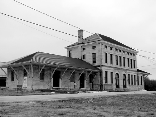
One of the earliest routes to ascend the Cumberland Plateau in the Monteagle area connected Sewanee at the top to Cowan down below. As the members of the Dixie Highway Association were looking for the best route to cross the plateau, they decided to reuse this early road, making improvements along the incline.

A more detailed description of this spot comes from the TDOT book Tennessee's Survey Report for Historic Highway Bridges on Page 125:
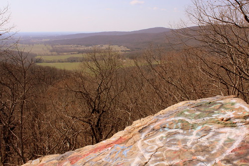
During the 1920s and 1930s, there was a growing interest nationally in scenic beautification projects along highways. These often included turnouts, or pull-offs, sometimes with small parks or picnic areas. If an impressive view existed, the turnout was called a scenic overlook. During the 1930s, beginning in 1934 in Tennessee, federal relief programs funded “Roadside Development,” “Landscaping,” and “Beautification” projects resulting in landscaping projects and a variety of roadside parks, pull-offs or turnouts, and overlooks. An example is the scenic overlook on the steep western side of Monteagle Mountain. In 1918 Franklin County issued a $300,000 bond issue for road improvements which included a joint project with the state in 1919 to improve a ten mile stretch of the Dixie Highway through the county that contained this pull-off. It is unknown if the original pull-off, which contained a sweeping 400 foot stone wall flanking a massive boulder, pre-dates the 1919 project or if it was built (or enhanced) as part of the project. In 1936 the state spent $11,190 as a National Recovery Highway Project to landscape 5.4 miles of the Cowan to Sewanee section of State Route 15 (the Dixie Highway). The 1936 project, whose plans show the location of the original stone wall, removed the older wall and erected a new wall of rubble masonry 1400 feet long, cut steps into the boulder (7” rise, 12” tread, and 30” width), and paved the parking area with macadam stone. The state also built over 900 discontiguous feet of rubble masonry walls and planted over 2100 trees and shrubbery “grouped in as natural arrangements as possible” on the project.

While the road was originally part of the Dixie Highway, and then state route TN15, eventually it became US41A/US64. (It is not US64 anymore as that route now meets I-24 and ascends Monteagle that way.) This area is right along the western edge of the Domain of the University of the South. The stone masonry that extends from the left of the boulder eventually meets up with the highway marking the western entrance of the University of the South. When you climb up the steps, you see the surface of the boulder is covered with graffiti covering graffiti. My personal favorite was "Don't fall of and die!!!" (Things dating back to the Thirties don't always have guardrails.) Even still, in the 10 minutes I was here, multiple carloads of young and old passengers stopped for family portraits.

Wednesday, March 29, 2017

Cookeville, TN Model Depot

Cookeville, TN Model Depot.

The wonderfully preserved Tennessee Central Depot in Cookeville, TN has been converted into a museum. As soon as you walk in, there's a model train display replicating what Cookeville looked like back when the depot was in use.

Tuesday, March 28, 2017

Tiptonville Veterans Park

Tiptonville Veterans Park

Located in Tiptonville across the street from the Lake County Courthouse.

Monday, March 27, 2017

Cumberland River Pedestrian Bridge

Cumberland River Pedestrian Bridge View #1

There are 15 bridges that cross the Cumberland River in Nashville, and this one is the newest after it opened in 2008. It is one of two pedestrian bridges, but the first one built specifically for that purpose. In it part of the Nashville Greenway system connecting Two Rivers Park on the south to Shelby Bottoms on the north. For more info: www.americantrails.org/resources/structures/Cumberland-Ri...

Cumberland River Pedestrian Bridge View #5

Sunday, March 26, 2017

St. John's Episcopal Church - Tuscumbia, AL

St. John's Episcopal Church - Tuscumbia, AL

from the historical marker:
This congregation was organized in the 1830s, with services being held in private homes and the Methodist meeting house. The present building was first used in October 1852 and completed the following year. During the Civil War, Union troops occupied the church and destroyed some of the parish records. St. John's is an early example of the "Carpenter's Gothic" style popular for many Episcopal churches during the mid-19th century. Damaged by a tornado in 1874, the church afterward was refurbished and strengthened with iron tie-rods spanning the nave. Memorial windows also were installed. Concrete buttresses were added in 1956. A tall spire originally topped the bell-tower.

Saturday, March 25, 2017

Hickman Springs Waterfall

Hickman Springs Waterfall C Wide angle view near base

Here's an easily accessible waterfall that I drove near 3 or 4 times without getting right up to it. You can see it from the street, Hickman Springs Rd.

The waterfall comes from a nearly flat area at the top, and then tumbles 20 feet to the base, where the water continues to trickle down the terrain.

Driving here is easy. Parking isn't. All the area at top is private property. There's a little space to pull over if you're driving back down the street.

Friday, March 24, 2017

Cordell Hull Dam

Cordell Hull Dam

According to Wikipedia:
Cordell Hull Lake is a lake in the Cumberland River in north-central Tennessee, about forty miles east of Nashville, in the vicinity of Carthage. It covers approximately 12,000 acres.

Cordell Hull Dam impounding the Cumberland River was built by the United States Army Corps of Engineers between May 1963 and November 1973 for navigation, hydroelectric power generation, and recreation. The dam is concrete and earthen gravity structure, 87 feet high (above streambed), with a generator capacity of 100 megawatts. It impounds 259,100 acre feet at normal maximum pool, with a maximum flood storage of 310,900 acre feet.

Both are named for Cordell Hull, former United States Secretary of State.

Thursday, March 23, 2017

Random Caboose at Casey Jones Village

Random Caboose at Casey Jones Village

As part of the Casey Jones Village mega tourist attraction is the Casey Jones Motel. Behind the motel are a couple of old passenger trains and this caboose. I don't know if this is part of a "sleep on an old train car" or just something else to see while in the area.

Wednesday, March 22, 2017

Carthage, TN lighthouse

Carthage, TN lighthouse

Near the bank of the Cumberland River in Carthage, TN is this lighthouse. The lighthouse is a masonry tower about 36 ft tall with a spiral staircase leading up to the gallery.

I can't find almost any information on this lighthouse, such as the date is was built. It is not listed with the U.S. Coast Guard, which means it never had the purpose of an aid to river navigation. This means that it was built for recreation or decorative purposes. If you know more, please share in the comments.

Tuesday, March 21, 2017

Coffee Co. Fair: Spider Ride

2013 Coffee Co. Fair: Spider Ride

Along the midway, the spider ride is a smaller fun thrill ride that spins people around as they bounce up and down. This is a blurred motion long exposure photo taken at dusk.

2013 Coffee Co. Fair: Spider Ride

Monday, March 20, 2017

In the news: Davy Crockett replica birthplace cabin to be replaced

Davy Crockett replica birthplace cabin

The place where Davy Crockett was born has been preserved at Davy Crockett Birthplace State Park near Limestone, TN in Greene County. By preserved, I mean the spot has been marked as the original log cabin is long gone. The state park has built a couple of replicas over the years and the one in the picture above was built in 1986 for the state's Bicentennial.

According to the story linked below, a new replica cabin is scheduled to be built and the one above will be preserved elsewhere in the park.

Greeneville Sun: Crockett Cabin Ready For Uprooting

nearly forgotten US60 Highway Sign

nearly forgotten US60 Highway Sign

I rarely see the shield-shaped US Highway signs anymore, or at least in the South. It's almost surprising nobody has stolen this one yet. This sign is near the Singing Bridge in downtown Frankfort, KY. I'd appreciate anyone guess as to how old it is.

When US60 was first routed through Frankfort, It came from the east along Main St., turned south on St. Clair where it passed this sign before crossing the bridge, and then continued west on Louisville Rd. Today, US60 crosses the Kentucky River along Capitol Ave and spends less time in the old, historic part of town. I'm not sure when the reroute happened, but instead of taking this sign down, they just added "TO" onto the sign.

Sunday, March 19, 2017

Sam Davis burial monument

Sam Davis burial monument

Sam Davis was the Boy Hero of the Confederacy during the Civil War. He is buried in a small cemetery behind his family's home in Smyrna, TN.

Saturday, March 18, 2017

Harold Lambert Overlook - Fort Dickerson Quarry

Harold Lambert Overlook - Fort Dickerson Quarry

This scenic spot not far from downtown Knoxville might be well known to the locals, but was a surprise for an out-of-towner like me. The water is so green, I should have posted this for St. Patrick's Day yesterday.

Several times over the years, I would pass through Knoxville along the Chapman Highway on the way to Gatlinburg. Not far after crossing the Tennessee River, I would see the steep drive on the west side of the road pointing up to Fort Dickerson. I often wondered what was up there, but I always forgot to research it further because I was on my way to Gatlinburg. In recent years, Knoxville, has made the road up there a little less steep, and more inviting.

In addition to the actual Civil War Fort Dickerson atop this small mountain, is this scenic overlook to the Fort Dickerson Quarry (aka Lambert Quarry). Now that water has filled into the quarry, it has turned into this emerald green color.

Not far from the Fort is Lambert Overlook. All one can do here is take a look as the city has installed some fencing to prevent people from trying to access the water from this side. You may be able to tell there is a road that leads down to the water on the other side.

For many years, the locals wanted this to be a swimming hole - a place of calm water so close to downtown. It was illegal for a long time, but a couple of years ago the city made it ok to swim here. However, swimming has it's risks as you choose to swim to the other side and get tired, you have to swim all the way back to where you started as there is only one place to enter and exit. Plus there have been a few people who made poor decisions and lost their life when jumping from the bluffs. This has forced the city to reconsider whether or not swimming should be permitted here.

Friday, March 17, 2017

Erin Go Bragh clover sign - Erin, TN

Erin Go Bragh clover sign - Erin, TN

"Erin Go Bragh" is a phrase used by Irish Immigrants which translates to "Ireland Forever." The city of Erin, TN in Houston County was originally settled by Irish immigrants and the town has retained its Irish heritage.

This distance and direction marker is located at the intersection of highways TN49 and TN149. Erin is a mile to the west and Dickson is 30 miles to the east. The sign also points out the Irish towns of Galway, Dublin and Shannon are about 4000 miles away.

Uploaded in honor of St. Patrick's Day 2017.

Thursday, March 16, 2017

Colemere / Monell's at the Manor - Nashville

Colemere / Monell's at the Manor - Nashville

The mansion shown here was originally the home of retired NCStL Railway President E.W. Cole. It was built in 1931 to replace the first mansion here which burned down. The area became an important property with its location along Murfreesboro Road (US41/70S) next door to the Nashville airport.

In 1948, a group of businessmen turned the mansion into a private club known as the Colemere Club. In 1977 it became the popular seafood restaurant New Orleans Manor. In 2011, southern family style buffet restaurant Monell's opened up a second location at the Manor.

Wednesday, March 15, 2017

King's Palace Cafe Neon Sign - Beale St.

King's Palace Cafe Neon Sign - Beale St.

Located on historic Beale St. in Memphis is the King's Palace Cafe. The restaurant and its neon sign are an iconic establishment on the iconic street.

Would you like to see more photos from Beale street? Check out the Beale Street gallery

Tuesday, March 14, 2017

Lauderdale County Courthouse Side - Ripley, TN

Lauderdale County Courthouse Side - Ripley, TN

The Colorful New Deal era Courthouse of Lauderdale County was built in 1936 at a cost of $120,000, in part paid for by the WPA. It is the forth courthouse to be built in the town square of Ripley, where the east and south sides are rather level, but the north and west side slopes quite a bit. The brick building is trimmed with stone and features Art Deco detailing. Sometimes Art Deco results in boring, uninspired boxy design, but this building has intricate detailing with well maintained grounds. Today, the courthouse is on the National Register of Historic Places.

Monday, March 13, 2017

Adventure Golf: Shark - Pigeon Forge, TN (Now gone)

Adventure Golf: Shark

Sadly, this place is now gone and it is a vacant lot. Here is my write-up from 8 years ago.

"Big Jim" Sidwell worked at his family's furniture business in Murfreesboro, TN. He was looking for an outlet for his creativity when he and his family visited Goofy Golf on a vacation to Florida. In his backyard, he built a large dinosaur out of wood and wire mesh, and then another and another.

In 1961, he opened Jolly Golf in Gatlinburg with many of his creations. He went on to build more mini golf parks in Daytona, Marietta and Lake of the Ozarks. When other attractions which also wanted his dinosaurs came calling, he started a fiberglass dinosaur factory in Murfreesboro. In the late 70's his tourist attraction vision expanded to a theme park in Pigeon Forge called Magic World.

At the gateway of the Smokies, tourist attractions come and go, but one of the Sidwell family's parks is still open. Pigeon Forge exploded in popularity once Gatlinburg couldn't expand anymore. Adventure Golf along US441 looks like it remains popular after all these years. It has a charm I like that many of the newer large corporate parks don't have.

There's a large Dinosaur by the entrance and a shark in the pond right by the 18th hole. Perhaps the most noticeable thing is the over-sized octopus in another pond and one of its many tentacles is raised up in the air!

Sunday, March 12, 2017

Greystone - Knoxville, TN

Greystone - Knoxville, TN

From Wikipedia:
Greystone, also called the Camp House, is a prominent historic home in Knoxville, Tennessee, that houses the studios and offices of WATE-TV. It is an imposing structure, and is on the National Register of Historic Places. The mansion is located at 1306 Broadway (US441).

Major Eldad Cicero Camp began constructing his home in 1885. Architect Alfred B. Mullet designed the mansion in the Richardson Romanesque style. Mullett had previously designed the Customs House building in downtown Knoxville. The home is two and a half stories, with a three-story tower in the front. The exterior of the home is sheathed in stone from a quarry in Lake City, Tennessee. The home contains elaborate hand-carved mantels from France. Each room is paneled in a different type of wood. The heads of windows include stained glass panels, and 22 different types of marble are used in the house. The site also includes a carriage house.

Major Camp was born in Ohio, served in the Union army during the Civil War, made Knoxville his home and was appointed a U.S. District Attorney by President Ulysses S. Grant.

The Camp family used the home until 1935. When Camp's heirs were no longer able to maintain the house, they sold some of the furnishings and subdivided the mansion into apartments. The condition of the building declined during its rental use, until WATE-TV purchased the building in 1965 at a cost of $75,000. Over the next two years, the mansion was restored and renovated for use by the television station. The restoration and renovation process cost $1.5 million. The first floor of the building was preserved and restored largely in its original form. A new 13,000-square-foot addition on the back of the building housed the station's studios. In April 1973, Greystone was added to the National Register of Historic Places.

Saturday, March 11, 2017

Cheatham County Bicentennial Trail Bridge

Cheatham County Bicentennial Trail Bridge (Ver. 4)

This bridge was originally built in 1901 by the Tennessee Central Railway as they extended their rail line from Nashville west to Clarksville. Around 1990, the tracks west of Ashland City were abandoned and soon many people wanted to convert the old railbed and this bridge to a pedestrian trail. With a partnership between the Rails-to-Trails Conservancy and the Cheatham County Parks Department, the Cumberland River Bicentennial Trail was built and it utilized the old bridge. (The trail parallels the Cumberland River but actually crosses Sycamore Creek.) The iron Parker through truss bridge with a length of 550 ft. was built by American Bridge Co.

For the full story: www.railstotrails.org/news/recurringfeatures/trailmonth/a...
or: www.cumberlandrivertrail.org/history.htm

Friday, March 3, 2017

The Delta Queen Eagle logo

The Delta Queen Eagle logo

The Eagle folding a flag and banner adorns the front of the Pilot House

for more pictures of the Delta Queen, check out my website's Coolidge Park gallery:
seemidtn.com/gallery/index.php?album=chattanooga%2Fcoolid...

Thursday, March 2, 2017

See Rock City barn - Ethridge, TN

See Rock City barn - Ethridge, TN

Along highway US43 between Columbia and Lawrenceburg is the small town of Ethridge, TN. Ethridge is best known for all the nearby Amish farms.

Many people come to Ethridge to buy various fresh produce. From there, a bunch of flea markets and antique stores describing themselves as Amish Tourist Information stops sprung up.

With all of the tourists coming to the area, this Rock City Barn now appears in the middle of it all. Despite the rust of the roof coming through the white paint, I believe this is one of the newer Rock City barns around.

For what it's worth, the "A Place of Rest Campground" is on an old Amish farm.

Wednesday, March 1, 2017

Columbia, TN Union Station

Columbia, TN Union Station (b&w)

The old Union Station in Columbia was built in 1902 replacing an older, long demolished, building that had stood nearby. It served the community for both Louisville & Nashville, NCStL and Duck River Valley Narrow Gauge Railroad and was in use until the 1960s when passenger service was discontinued with cancelled freight and parcel service following. This building once served as one of the hubs of the community but is unused and neglected today despite its presence on the National Register of Historic Places.